|
search place name
|
||
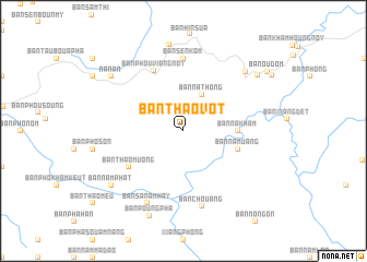
Ban Thaovot (Xiangkhoang, Laos)Ban Thaovot is a town in the Xiangkhoang region of Laos. An overview map of the region around Ban Thaovot is displayed below.
regional and 3d topo map of Ban Thaovot, Laos ::
Ban Thaovot airports ::
The nearest airport is LPQ - Luang Prabang Luang Phabang Intl, located 71.6 km north west of Ban Thaovot.
Other airports nearby include VTE - Vientiane Wattay Intl (158.2 km south), LOE - Loei (238.4 km south west), Nearby towns ::
Ban Houay Say (4.1km north east) //
Ban Nathong (4.1km north east) //
Ban Nakham (5.2km east) //
Ban Khangthôn (5.6km east) //
Ban Namuang (5.6km east) //
Ban Thao Muong (6.4km south west) //
Ban Phouviang-Noy (6.8km north west) //
Ban Sèn Kôm (7.4km north) //
Ban Chouang (7.9km south) //
Ban Sanam Hay (8.2km south west) //
Ban Hinlak (8.5km north east) //
Ban Viangchaleun (8.9km north) //
Na Nan (8.9km north west) //
Ban Nam Phat (8.9km south west) //
Ban Poungpha (9.3km south) //
Ban Sômboun (9.1km north east) //
Ban Oudôm (10.1km north east) //
[all distances 'as the bird flies' and approximate]  Places with similar names to Ban Thaovot, Laos ::
// Ban Tha Fat (TH)
// Ban Tha Fa Tai (TH)
// Ban Tha Phet (TH)
// Ban Tha Phut (TH)
// Ban Thaphô Tai (LA)
Disclaimer :: Information on this page comes without warranty of any kind |
||
|
Where is Ban Thaovot? Elevation and coordinates ::
Latitude (lat): 19°25'0"N Longitude (lon): 102°37'0"E
Elevation (approx.): 1413m (map arrows pan, magnifying glasses zoom) |
||
|
Visiting Ban Thaovot? Hotel/Accommodation ::
Book a hotel in Ban Thaovot Travel Guide ::
Buy a travel guide for Laos rental cars ::
car rental offers GPS waypoint ::
download a GPX waypoint (PoI) of Ban Thaovot for your GPS receiver
|
||