|
search place name
|
||
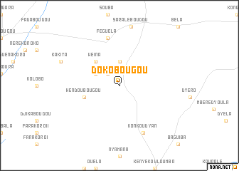
Dokobougou (Mali)Dokobougou is a town in Mali. An overview map of the region around Dokobougou is displayed below.
regional and 3d topo map of Dokobougou, Mali ::
Dokobougou airports ::
The nearest airport is BKO - Bamako Senou, located 150.7 km west of Dokobougou.
Nearby towns ::
Dyokon (2.6km north west) //
Mbayabougou (3.7km north) //
Barakabougou (4.1km north west) //
Weïna (5.2km north west) //
Wendoubougou (5.7km west) //
Féguéla (7.6km north) //
Konkoudyan (8.2km south east) //
[all distances 'as the bird flies' and approximate] 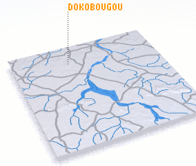 Places with similar names to Dokobougou, Mali ::
// Dagubek (PH)
// Dağbağ (TR)
// Dukubaka (GH)
// Digobuke (TZ)
// Dāki Baihk (PK)
// Doga Baihk (PK)
// Digabougou (ML)
// Dokabougou (ML)
// Tigabougou (ML)
// Tugbok (PH)
Disclaimer :: Information on this page comes without warranty of any kind |
||
|
Where is Dokobougou? Elevation and coordinates ::
Latitude (lat): 12°51'0"N Longitude (lon): 6°36'0"W
Elevation (approx.): 338m (map arrows pan, magnifying glasses zoom) |
||
|
Visiting Dokobougou? Hotel/Accommodation ::
Book a hotel in Dokobougou Travel Guide ::
Buy a travel guide for Mali rental cars ::
car rental offers GPS waypoint ::
download a GPX waypoint (PoI) of Dokobougou for your GPS receiver
|
||