|
search place name
|
||
Kati (Koulikoro, Mali)Kati is a town in the Koulikoro region of Mali. An overview map of the region around Kati is displayed below.
regional and 3d topo map of Kati, Mali ::

Kati airports ::
The nearest airport is BKO - Bamako Senou, located 27.0 km south east of Kati.
Nearby towns ::
Koko (1.2km north west) //
Sananfara (2.4km south east) //
Ntoubana (3.0km north east) //
Farada (3.5km north west) //
Ntonimba (4.6km south west) //
Kolébabougou (5.1km east) //
Sirakoro (5.6km south) //
Konobougou (5.5km west) //
Babougou (5.8km north east) //
Sirakoro (5.9km east) //
Sébéninkoro (5.9km west) //
Falaninko (5.9km east) //
Tana (6.1km north west) //
Sikoro (6.2km south) //
Mpiébougou (6.3km south west) //
Dounfing (6.5km south) //
Ouadougou Sikoro (6.6km south) //
Kambila (6.6km north west) //
Banambani (6.6km north east) //
Torodo (7.1km south west) //
Doniambougou (7.5km west) //
Ntyènéguébougou (8.0km north) //
Nkomi (8.1km south east) //
Tyètimbougou (8.6km north west) //
Sogonafing (9.0km south east) //
Samé (9.0km south east) //
Makono (9.6km south west) //
Koulouba (10.3km south east) //
Koulouba (11.8km south east) //
[all distances 'as the bird flies' and approximate] 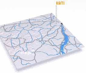 Places with similar names to Kati, Mali ::
Disclaimer :: Information on this page comes without warranty of any kind |
||
|
Where is Kati? Elevation and coordinates ::
Latitude (lat): 12°44'48"N Longitude (lon): 8°4'17"W
Elevation (approx.): 429m (map arrows pan, magnifying glasses zoom) |
||
|
Visiting Kati? Hotel/Accommodation ::
Book a hotel in Kati Travel Guide ::
Buy a travel guide for Mali rental cars ::
car rental offers GPS waypoint ::
download a GPX waypoint (PoI) of Kati for your GPS receiver
|
||