|
search place name
|
||
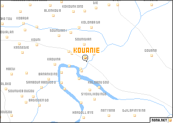
Kouanié (Koulikoro, Mali)Kouanié is a town in the Koulikoro region of Mali. An overview map of the region around Kouanié is displayed below.
regional and 3d topo map of Kouanié, Mali ::
Kouanié airports ::
The nearest airport is BKO - Bamako Senou, located 100.8 km west of Kouanié.
Nearby towns ::
Damanko (2.1km south west) //
Founébougou (2.3km south west) //
Fousseynibougou (2.3km north east) //
Nouaninkoro (3.6km north west) //
Sounidian (3.8km north) //
Baninkoro (3.8km west) //
Mossibougou Faradiè (4.1km south west) //
Daoudabougou (4.4km north west) //
Tougouninbougou (5.8km south west) //
Tamatoumbougou (6.2km south) //
Kolobougou (6.2km south east) //
Kaouina (6.8km west) //
Drissabougou (7.0km south west) //
Sirakoro Soundian (7.1km north west) //
Kolombada (7.4km north) //
Kobili (7.6km north) //
Sido (7.5km south west) //
Soundiani (8.2km north west) //
Syèkilikoungo (8.3km south) //
Banankoro (8.9km south west) //
[all distances 'as the bird flies' and approximate] 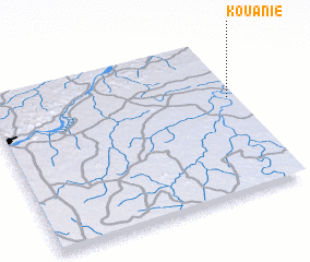 Places with similar names to Kouanié, Mali ::
Disclaimer :: Information on this page comes without warranty of any kind |
||
|
Where is Kouanié? Elevation and coordinates ::
Latitude (lat): 12°37'20"N Longitude (lon): 7°1'37"W
Elevation (approx.): 303m (map arrows pan, magnifying glasses zoom) |
||
|
Visiting Kouanié? Hotel/Accommodation ::
Book a hotel in Kouanié Travel Guide ::
Buy a travel guide for Mali rental cars ::
car rental offers GPS waypoint ::
download a GPX waypoint (PoI) of Kouanié for your GPS receiver
|
||