|
search place name
|
||
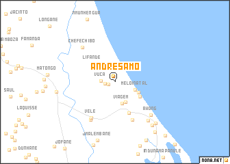
André Samo (Inhambane, Mozambique)André Samo is a town in the Inhambane region of Mozambique. An overview map of the region around André Samo is displayed below.
regional and 3d topo map of André Samo, Mozambique ::
André Samo airports ::
The nearest airport is VNX - Vilankulu Vilankulo, located 62.8 km south of André Samo.
Other airports nearby include BEW - Beira (187.3 km north), Nearby towns ::
Muriane (1.1km west) //
Chipunda (1.5km west) //
Vuca (2.1km west) //
Meloi Natal (3.3km south east) //
Viagem (3.7km south) //
Faduco (3.7km south east) //
Sinal (3.9km south east) //
Lifande (4.5km north west) //
Albano (4.5km south east) //
Chibal (5.5km south east) //
Chefe Petane (6.8km south east) //
Vele (6.8km south west) //
Massilico (7.2km south west) //
Chefe Chibo (7.4km north west) //
A. Wong (7.7km south east) //
Régulo Chibamo (8.1km south east) //
Chaculane (9.0km south east) //
Inhassoro (9.2km south east) //
Juga (10.3km south east) //
Ky Hong (11.6km south east) //
[all distances 'as the bird flies' and approximate] 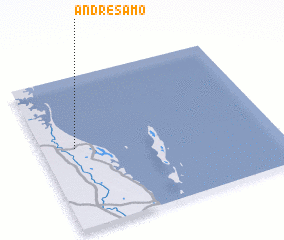 Places with similar names to André Samo, Mozambique ::
// Andrasemba (MG)
Disclaimer :: Information on this page comes without warranty of any kind |
||
|
Where is André Samo? Elevation and coordinates ::
Latitude (lat): 21°28'26"S Longitude (lon): 35°8'32"E
Elevation (approx.): 41m (map arrows pan, magnifying glasses zoom) |
||
|
Visiting André Samo? Hotel/Accommodation ::
Book a hotel in André Samo Travel Guide ::
Buy a travel guide for Mozambique rental cars ::
car rental offers GPS waypoint ::
download a GPX waypoint (PoI) of André Samo for your GPS receiver
|
||