|
search place name
|
||
Cabo Madaia (Inhambane, Mozambique)Cabo Madaia is a town in the Inhambane region of Mozambique. An overview map of the region around Cabo Madaia is displayed below.
regional and 3d topo map of Cabo Madaia, Mozambique ::

Cabo Madaia airports ::
The nearest airport is INH - Inhambane, located 70.1 km south east of Cabo Madaia.
Other airports nearby include VNX - Vilankulu Vilankulo (148.6 km north), Nearby towns ::
Induna A. Somane (2.0km south) //
Seangamo (3.6km north west) //
Reginaldo (4.3km north east) //
Cabo Manhaucela (4.3km south west) //
Cabo Dimande III (4.9km north west) //
Alfanete (5.9km north) //
Alberto (5.9km east) //
João (6.5km south) //
Cabo Leonzuane (7.6km south east) //
Uinge (8.0km north east) //
Penane (8.8km north west) //
Tiane (10.6km north east) //
[all distances 'as the bird flies' and approximate] 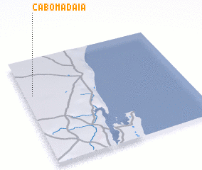 Places with similar names to Cabo Madaia, Mozambique ::
// Gabia Mata (ET)
// Kabambata (CD)
// Kiba Amadou (NE)
// Gbambiadu (SL)
// Cabo Amito (MZ)
// Cabo Mata (MZ)
Disclaimer :: Information on this page comes without warranty of any kind |
||
|
Where is Cabo Madaia? Elevation and coordinates ::
Latitude (lat): 23°20'16"S Longitude (lon): 35°2'52"E
Elevation (approx.): 100m (map arrows pan, magnifying glasses zoom) |
||
|
Visiting Cabo Madaia? Hotel/Accommodation ::
Book a hotel in Cabo Madaia Travel Guide ::
Buy a travel guide for Mozambique rental cars ::
car rental offers GPS waypoint ::
download a GPX waypoint (PoI) of Cabo Madaia for your GPS receiver
|
||