|
search place name
|
||
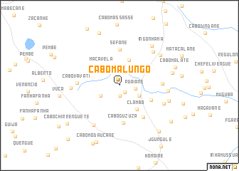
Cabo Malungo (Inhambane, Mozambique)Cabo Malungo is a town in the Inhambane region of Mozambique. An overview map of the region around Cabo Malungo is displayed below.
regional and 3d topo map of Cabo Malungo, Mozambique ::
Cabo Malungo airports ::
The nearest airport is INH - Inhambane, located 33.3 km east of Cabo Malungo.
Other airports nearby include VNX - Vilankulu Vilankulo (195.7 km north), Nearby towns ::
Mualungo (1.4km south east) //
Cabo Marrinhela (1.7km south) //
Cabo Dorete (2.4km north) //
P. Daiane (2.4km east) //
Cabo Chicuarro (3.2km south west) //
Régulo Machavela (3.3km south east) //
Benguane (3.6km north east) //
Macavela (3.9km north west) //
Cabo Séfane (4.2km north) //
C. Lambo (4.4km south east) //
Ingovene (5.1km south east) //
Séfane (5.6km north) //
Cabo Guzuza (5.9km south) //
Cabo Mahala (6.0km south east) //
Cabo Vaváti (6.1km west) //
N. Foquiço (6.2km east) //
Cabo Maueua (7.2km north east) //
Cabo Daulamaze (7.3km south west) //
F. Utela (7.0km south east) //
Vavate (7.0km west) //
T. Mungasi (7.1km east) //
Ingónhama (7.8km north east) //
Inguani (7.6km north east) //
Matimbe (7.5km east) //
Cabo Cheocule (7.9km east) //
Banhane (8.7km north) //
Cabo Malate (8.5km east) //
J. Jossia (9.1km south east) //
Cabo Modaucane (9.5km south) //
[all distances 'as the bird flies' and approximate] 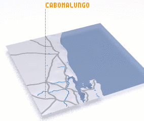 Places with similar names to Cabo Malungo, Mozambique :: Disclaimer :: Information on this page comes without warranty of any kind |
||
|
Where is Cabo Malungo? Elevation and coordinates ::
Latitude (lat): 23°46'30"S Longitude (lon): 35°6'2"E
Elevation (approx.): 149m (map arrows pan, magnifying glasses zoom) |
||
|
Visiting Cabo Malungo? Hotel/Accommodation ::
Book a hotel in Cabo Malungo Travel Guide ::
Buy a travel guide for Mozambique rental cars ::
car rental offers GPS waypoint ::
download a GPX waypoint (PoI) of Cabo Malungo for your GPS receiver
|
||