|
search place name
|
||
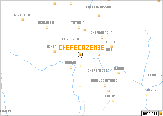
Chefe Cazembe (Zambézia, Mozambique)Chefe Cazembe is a town in the Zambézia region of Mozambique. An overview map of the region around Chefe Cazembe is displayed below.
regional and 3d topo map of Chefe Cazembe, Mozambique ::
Chefe Cazembe airports ::
The nearest airport is BLZ - Blantyre Chileka Intl, located 94.5 km west of Chefe Cazembe.
Other airports nearby include UEL - Quelimane (242.2 km south east), Nearby towns ::
Chefe Sirapa (1.9km south) //
Mambucha (2.6km north) //
Namaja (3.2km south west) //
Chefe Cuetenque (3.9km east) //
Likangala (4.1km north west) //
Chefe Tocota (5.6km south east) //
Nchenga (6.1km west) //
Chefe Duia (6.6km north) //
Chefe Jeroma (6.6km north east) //
Chefe Sirabo (6.7km south) //
Tuthuwa (7.1km north) //
Tundo (7.1km east) //
Taúlo (7.5km north) //
Régulo Chitambo (8.2km south east) //
Meloiua (8.9km south east) //
Chefe Sumbe (9.7km south east) //
Nkulambe (10.4km north west) //
[all distances 'as the bird flies' and approximate] 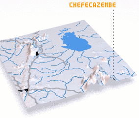 Places with similar names to Chefe Cazembe, Mozambique ::
Disclaimer :: Information on this page comes without warranty of any kind |
||
|
Where is Chefe Cazembe? Elevation and coordinates ::
Latitude (lat): 15°54'48"S Longitude (lon): 35°49'19"E
Elevation (approx.): 708m (map arrows pan, magnifying glasses zoom) |
||
|
Visiting Chefe Cazembe? Hotel/Accommodation ::
Book a hotel in Chefe Cazembe Travel Guide ::
Buy a travel guide for Mozambique rental cars ::
car rental offers GPS waypoint ::
download a GPX waypoint (PoI) of Chefe Cazembe for your GPS receiver
|
||