|
search place name
|
||
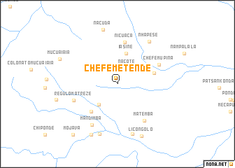
Chefe Metende (Niassa, Mozambique)Chefe Metende is a town in the Niassa region of Mozambique. An overview map of the region around Chefe Metende is displayed below.
regional and 3d topo map of Chefe Metende, Mozambique ::
Chefe Metende airports ::
The nearest airport is VXC - Lichinga, located 121.7 km north of Chefe Metende.
Other airports nearby include BLZ - Blantyre Chileka Intl (171.4 km south west), LLW - Lilongwe Kamuzu Intl (213.4 km west), Nearby towns ::
Nacote (2.9km north east) //
Cardoso (4.4km south west) //
Iasine (5.1km north) //
Uncuavira (5.9km south west) //
Licuacua (5.9km east) //
Nicuaca (6.7km north) //
Matemba (7.2km south east) //
Chefe Mupina (7.1km north east) //
Régulo Matreze (7.3km west) //
Mandimba (7.6km south west) //
Ermino (8.3km south) //
Abudo (8.4km south) //
Nhapese (8.4km north east) //
Nacuda (8.9km north) //
Antigo Pôsto de Mandimba (9.0km south west) //
Licongolo (9.1km south east) //
Mojava (10.6km south west) //
[all distances 'as the bird flies' and approximate] 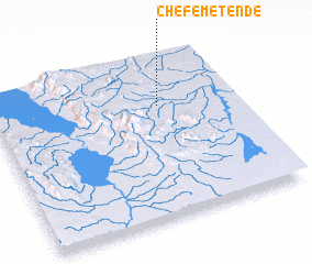 Places with similar names to Chefe Metende, Mozambique ::
// Chefe Madondo (MZ)
// Chefe Matanato (MZ)
Disclaimer :: Information on this page comes without warranty of any kind |
||
|
Where is Chefe Metende? Elevation and coordinates ::
Latitude (lat): 14°17'39"S Longitude (lon): 35°41'15"E
Elevation (approx.): 760m (map arrows pan, magnifying glasses zoom) |
||
|
Visiting Chefe Metende? Hotel/Accommodation ::
Book a hotel in Chefe Metende Travel Guide ::
Buy a travel guide for Mozambique rental cars ::
car rental offers GPS waypoint ::
download a GPX waypoint (PoI) of Chefe Metende for your GPS receiver
|
||