|
search place name
|
||
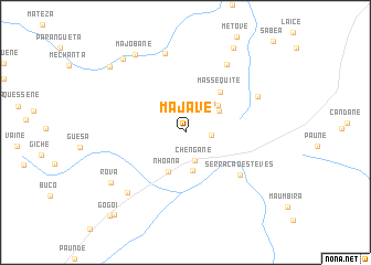
Majave (Manica, Mozambique)Majave is a town in the Manica region of Mozambique. An overview map of the region around Majave is displayed below.
regional and 3d topo map of Majave, Mozambique ::
Majave airports ::
The nearest airport is BFO - Chiredzi Buffalo Range, located 177.0 km south west of Majave.
Other airports nearby include BEW - Beira (198.5 km east), Nearby towns ::
Nhamutando (2.5km east) //
Chengane (3.0km south) //
Nhacha (3.9km south) //
Biquisa (3.9km north east) //
Filomone (3.9km north east) //
Bundua (4.1km north east) //
Nhoana (4.3km south) //
Massequite (5.2km north east) //
Serração Esteves (6.7km south east) //
Mandava (7.9km north east) //
Chamasi (7.8km north east) //
Chissamo (8.2km north) //
Bacequete (8.2km south west) //
Rova (8.7km south west) //
Majobane (9.3km north west) //
Eripa (9.5km north west) //
Manjacha (9.6km north east) //
Mafussi (9.8km north west) //
Condana (10.7km south west) //
Gogói (11.1km south west) //
[all distances 'as the bird flies' and approximate] 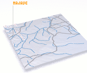 Places with similar names to Majave, Mozambique ::
Disclaimer :: Information on this page comes without warranty of any kind |
||
|
Where is Majave? Elevation and coordinates ::
Latitude (lat): 20°14'37"S Longitude (lon): 33°4'14"E
Elevation (approx.): 472m (map arrows pan, magnifying glasses zoom) |
||
|
Visiting Majave? Hotel/Accommodation ::
Book a hotel in Majave Travel Guide ::
Buy a travel guide for Mozambique rental cars ::
car rental offers GPS waypoint ::
download a GPX waypoint (PoI) of Majave for your GPS receiver
|
||