|
search place name
|
||
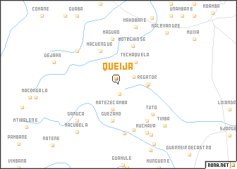
Queija (Maputo, Mozambique)Queija is a town in the Maputo region of Mozambique. An overview map of the region around Queija is displayed below.
regional and 3d topo map of Queija, Mozambique ::
Queija airports ::
The nearest airport is MPM - Maputo, located 52.6 km south east of Queija.
Other airports nearby include SZK - Skukuza (97.0 km north west), MTS - Manzini Matsapha (122.1 km south west), HDS - Hoedspruit Afb (182.0 km north west), PHW - Phalaborwa (217.6 km north west), Nearby towns ::
Cicuca (1.5km south) //
Meconguedza (2.4km north east) //
Matezecamba (4.0km south) //
Techaquela (4.3km north east) //
Guela (4.1km east) //
Regator (4.3km east) //
Guezamo (5.8km south) //
Macuengue (5.9km north west) //
Motechisse (6.4km north) //
Tuto (6.8km south east) //
Maguão (7.3km north) //
Utongo (7.1km south east) //
Guimbano (7.5km south) //
Maloi (7.8km south) //
Incalane (8.0km north west) //
Ganuca (8.3km south west) //
Muchava (8.7km south east) //
Bomucuba (9.2km south east) //
Timba (9.3km south east) //
Macubela (9.6km south west) //
M. Alexandre (10.6km north east) //
[all distances 'as the bird flies' and approximate] 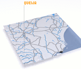 Places with similar names to Queija, Mozambique ::
Disclaimer :: Information on this page comes without warranty of any kind |
||
|
Where is Queija? Elevation and coordinates ::
Latitude (lat): 25°41'53"S Longitude (lon): 32°6'32"E
Elevation (approx.): 210m (map arrows pan, magnifying glasses zoom) |
||
|
Visiting Queija? Hotel/Accommodation ::
Book a hotel in Queija Travel Guide ::
Buy a travel guide for Mozambique rental cars ::
car rental offers GPS waypoint ::
download a GPX waypoint (PoI) of Queija for your GPS receiver
|
||