|
search place name
|
||
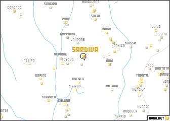
Sardiva (Zambézia, Mozambique)Sardiva is a town in the Zambézia region of Mozambique. An overview map of the region around Sardiva is displayed below.
regional and 3d topo map of Sardiva, Mozambique ::
Sardiva airports ::
The nearest airport is UEL - Quelimane, located 119.7 km south west of Sardiva.
Nearby towns ::
Nhazombe (0.8km north) //
Magia (1.2km south west) //
Nhaza (1.2km north) //
Zatava (3.7km west) //
Jampane (4.1km north) //
Madia (4.2km east) //
Mulabua (4.7km east) //
Meiro (4.9km west) //
Pacala (5.2km south) //
Nepiode (5.2km west) //
Madi (5.3km east) //
Mussali (5.3km east) //
Murraoia (6.2km north west) //
Peha (6.6km east) //
Mujaide (6.8km south) //
Chuanguete (6.8km west) //
Murrumo (7.1km north east) //
Abacar (7.2km north east) //
Chinga (7.2km north east) //
Mucacassi (7.4km north east) //
Naimo (7.6km north east) //
Manhica (7.5km east) //
Sousa (8.6km north west) //
Natudo (8.7km south east) //
Robê (9.2km north west) //
Livavia (9.3km north west) //
[all distances 'as the bird flies' and approximate] 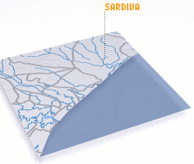 Places with similar names to Sardiva, Mozambique ::
Disclaimer :: Information on this page comes without warranty of any kind |
||
|
Where is Sardiva? Elevation and coordinates ::
Latitude (lat): 17°13'15"S Longitude (lon): 37°46'55"E
Elevation (approx.): 55m (map arrows pan, magnifying glasses zoom) |
||
|
Visiting Sardiva? Hotel/Accommodation ::
Book a hotel in Sardiva Travel Guide ::
Buy a travel guide for Mozambique rental cars ::
car rental offers GPS waypoint ::
download a GPX waypoint (PoI) of Sardiva for your GPS receiver
|
||