|
search place name
|
||
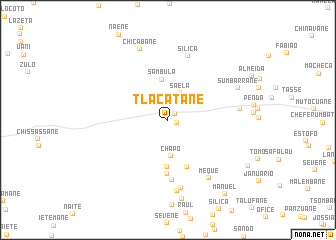
Tlacatane (Inhambane, Mozambique)Tlacatane is a town in the Inhambane region of Mozambique. An overview map of the region around Tlacatane is displayed below.
regional and 3d topo map of Tlacatane, Mozambique ::
Tlacatane airports ::
The nearest airport is VNX - Vilankulu Vilankulo, located 63.0 km east of Tlacatane.
Nearby towns ::
Tauhene (1.0km north east) //
Tai (1.0km east) //
Saela (3.2km north east) //
Chapo (4.1km south) //
Sambula (4.5km north) //
Chauane (5.2km south) //
Tauozene (5.6km south) //
Souquisse (6.1km south) //
Sefane (6.7km south) //
Silica (7.4km north) //
Satane (7.7km south) //
Meque (7.8km south east) //
Fiouce (8.0km south) //
Chaimel (7.6km east) //
Chicabane (8.4km north) //
Sumbarrane (8.0km north east) //
Sainda (8.9km south) //
Laquene (9.8km south east) //
Manuel (10.2km south east) //
[all distances 'as the bird flies' and approximate]  Places with similar names to Tlacatane, Mozambique ::
Disclaimer :: Information on this page comes without warranty of any kind |
||
|
Where is Tlacatane? Elevation and coordinates ::
Latitude (lat): 21°48'43"S Longitude (lon): 34°44'42"E
Elevation (approx.): 120m (map arrows pan, magnifying glasses zoom) |
||
|
Visiting Tlacatane? Hotel/Accommodation ::
Book a hotel in Tlacatane Travel Guide ::
Buy a travel guide for Mozambique rental cars ::
car rental offers GPS waypoint ::
download a GPX waypoint (PoI) of Tlacatane for your GPS receiver
|
||