|
search place name
|
||
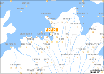
Jajau (Papua New Guinea)Jajau is a town in Papua New Guinea. An overview map of the region around Jajau is displayed below.
regional and 3d topo map of Jajau, Papua New Guinea ::
Jajau airports ::
The nearest airport is POM - Port Moresby Jacksons Intl, located 124.6 km south west of Jajau.
Nearby towns ::
Ajase (1.9km north) //
Kanari (1.9km south) //
Baru (1.9km south) //
Potura (1.8km west) //
Waru (1.8km east) //
Poha (1.8km west) //
Papoga (2.6km south west) //
Iwore (2.6km south east) //
Togahau (3.7km west) //
Ongoho (3.7km north) //
Towayik (3.7km north) //
Ivisusu (4.1km north west) //
Kura (4.1km south east) //
Tunana (4.1km south west) //
Doita (5.5km west) //
Perombaturu (5.5km west) //
Ondahari (5.6km north) //
Waiu (5.5km east) //
Huembo (6.7km south west) //
Ahora (6.7km north east) //
Oiere (6.7km north east) //
Hujavasusu (6.6km south west) //
Javeneri (7.3km west) //
Epa (7.6km north) //
Girigirita (7.6km north) //
Sirembi (7.6km west) //
Sehoro (7.8km north east) //
Bumburata (9.2km south east) //
[all distances 'as the bird flies' and approximate] 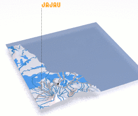 Places with similar names to Jajau, Papua New Guinea ::
Disclaimer :: Information on this page comes without warranty of any kind |
||
|
Where is Jajau? Elevation and coordinates ::
Latitude (lat): 8°44'0"S Longitude (lon): 148°6'0"E
Elevation (approx.): 110m (map arrows pan, magnifying glasses zoom) |
||
|
Visiting Jajau? Hotel/Accommodation ::
Book a hotel in Jajau Travel Guide ::
rental cars ::
car rental offers GPS waypoint ::
download a GPX waypoint (PoI) of Jajau for your GPS receiver
|
||