|
search place name
|
||
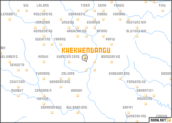
Kwekwendangu (Papua New Guinea)Kwekwendangu is a town in Papua New Guinea. An overview map of the region around Kwekwendangu is displayed below.
regional and 3d topo map of Kwekwendangu, Papua New Guinea ::
Kwekwendangu airports ::
The nearest airport is LAE - Nadzab, located 88.2 km west of Kwekwendangu.
Other airports nearby include MAG - Madang (236.7 km north west), Nearby towns ::
Doing (1.9km south) //
Sananga (1.8km east) //
Sanzeng (1.9km north) //
Pindiu (1.9km north) //
Safifi (2.6km south east) //
Kwenzenzeng (3.7km west) //
Zenguru (4.1km north west) //
Zalimpa (5.2km south west) //
Gemaheng (5.6km north) //
Bantamu (5.6km north) //
Bongganko (5.5km east) //
Wagazaring (5.9km north) //
Bwakugu (5.9km north) //
Afong (6.7km north east) //
Silimana (6.7km north east) //
Ebabang (6.7km south west) //
Hamoronong (6.7km north east) //
Pafiu (6.7km north east) //
Yapang (6.7km north west) //
Bulu (7.4km north) //
Wamuri (7.6km south) //
Esianda (7.6km north) //
Magedzetzu (7.6km north) //
Hamaronong (7.8km south west) //
Embewanang (8.2km south east) //
Ungesu (8.3km north west) //
Berakwaiyu (8.3km north west) //
Satneng (8.2km north west) //
[all distances 'as the bird flies' and approximate] 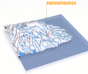 Places with similar names to Kwekwendangu, Papua New Guinea :: Disclaimer :: Information on this page comes without warranty of any kind |
||
|
Where is Kwekwendangu? Elevation and coordinates ::
Latitude (lat): 6°28'0"S Longitude (lon): 147°31'0"E
Elevation (approx.): 985m (map arrows pan, magnifying glasses zoom) |
||
|
Visiting Kwekwendangu? Hotel/Accommodation ::
Book a hotel in Kwekwendangu Travel Guide ::
rental cars ::
car rental offers GPS waypoint ::
download a GPX waypoint (PoI) of Kwekwendangu for your GPS receiver
|
||