|
search place name
|
||
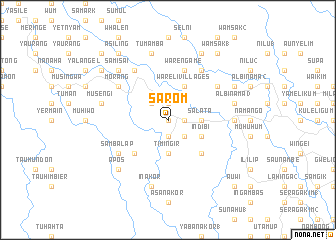
Sarom (Papua New Guinea)Sarom is a town in Papua New Guinea. An overview map of the region around Sarom is displayed below.
regional and 3d topo map of Sarom, Papua New Guinea ::
Sarom airports ::
The nearest airport is WWK - Wewak Intl, located 91.1 km east of Sarom.
Nearby towns ::
Bonahoi (0.0km north) //
M'bras (1.9km south) //
Wa'ahun (1.9km south) //
Luwaite Villages (1.9km north) //
Aluwingei (1.8km east) //
Waragom (1.8km east) //
Urita (2.6km south east) //
Bombita (2.6km south east) //
Saunes (2.6km south east) //
Emul (2.6km north west) //
Alumi (2.6km north west) //
Timingir (3.7km south) //
Salata (3.7km east) //
Indibi (4.1km south east) //
Wareli Villages (4.1km north east) //
Musengai (5.2km south west) //
Musendai (5.2km south west) //
Takua'agas Villages (5.2km south east) //
Warengame (5.9km north) //
Sambalap (6.7km south west) //
Pelnandu (6.7km north west) //
Bana (6.7km north east) //
Morang (6.7km north west) //
Bulamita (6.7km north east) //
Balif (7.4km east) //
Inakor (7.6km south) //
Musengi (7.6km west) //
Tumamba (7.6km north) //
Albinama 3 (7.6km east) //
[all distances 'as the bird flies' and approximate] 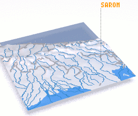 Places with similar names to Sarom, Papua New Guinea ::
Disclaimer :: Information on this page comes without warranty of any kind |
||
|
Where is Sarom? Elevation and coordinates ::
Latitude (lat): 3°37'0"S Longitude (lon): 142°51'0"E
Elevation (approx.): 229m (map arrows pan, magnifying glasses zoom) |
||
|
Visiting Sarom? Hotel/Accommodation ::
Book a hotel in Sarom Travel Guide ::
rental cars ::
car rental offers GPS waypoint ::
download a GPX waypoint (PoI) of Sarom for your GPS receiver
|
||