|
search place name
|
||
Zewitzan (Papua New Guinea)Zewitzan is a town in Papua New Guinea. An overview map of the region around Zewitzan is displayed below.
regional and 3d topo map of Zewitzan, Papua New Guinea ::

Zewitzan airports ::
The nearest airport is LAE - Nadzab, located 72.9 km west of Zewitzan.
Other airports nearby include GKA - Goroka (225.5 km west), MAG - Madang (228.4 km north west), Nearby towns ::
Ubaneng (0.0km north) //
Numbut (1.9km south) //
Semgeta (3.7km north) //
Aregenang (4.1km north east) //
Zengaren (5.8km east) //
Ogeramnang (5.9km north) //
Selimbeng (5.9km north) //
Tumnang (5.8km east) //
Kotkin (6.7km south east) //
Mindik (7.8km north east) //
Maran (8.3km north west) //
Keili (9.2km north west) //
Sanaronong (9.2km south east) //
Dubi (9.2km north west) //
Kor (10.5km north west) //
[all distances 'as the bird flies' and approximate] 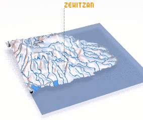 Places with similar names to Zewitzan, Papua New Guinea ::
// Zwätzen (DE)
// Zwötzen (DE)
// Zawidzyn (PL)
// Hsi-wei-ts'un (TW)
// Ssu-wei-ts'un (TW)
// Ssu-wei-ts'un (TW)
// Zewitzan (PG)
Disclaimer :: Information on this page comes without warranty of any kind |
||
|
Where is Zewitzan? Elevation and coordinates ::
Latitude (lat): 6°31'0"S Longitude (lon): 147°23'0"E
Elevation (approx.): 1132m (map arrows pan, magnifying glasses zoom) |
||
|
Visiting Zewitzan? Hotel/Accommodation ::
Book a hotel in Zewitzan Travel Guide ::
rental cars ::
car rental offers GPS waypoint ::
download a GPX waypoint (PoI) of Zewitzan for your GPS receiver
|
||