|
search place name
|
||
Benbesle (Bay, Somalia)Benbesle is a town in the Bay region of Somalia. An overview map of the region around Benbesle is displayed below.
regional and 3d topo map of Benbesle, Somalia ::
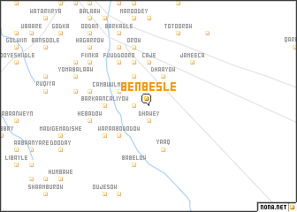
Nearby towns ::
Dhawey (1.9km south) //
Guunyo Rooble (1.9km west) //
Dhaayow (4.1km north east) //
Cambuul Weyne (4.1km north west) //
Cambuul Madhabey (4.1km north west) //
Waraabo Dodow (5.2km south west) //
Barkaan Caliyow (5.6km west) //
Caje (5.6km north) //
Yaaq (5.9km south) //
Cambuul Lebi (5.9km north) //
Cambuul Xaraar (5.9km north) //
Garangarow (6.7km south west) //
Fuud Dooro (6.7km north west) //
Orow (7.6km north) //
Abaar Yoma (7.6km west) //
Hebadow (7.6km west) //
Babelow (7.6km south) //
Jameeca (7.9km north east) //
Gogolis (8.3km north west) //
Fiinka (9.3km north west) //
Hagarrow (10.5km north west) //
[all distances 'as the bird flies' and approximate] 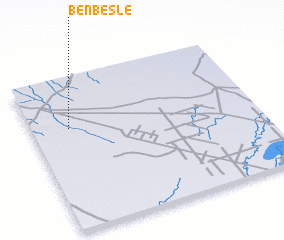 Places with similar names to Benbesle, Somalia ::
// Ban Bo Sali (TH)
// Banbusul (SO)
Disclaimer :: Information on this page comes without warranty of any kind |
||
|
Where is Benbesle? Elevation and coordinates ::
Latitude (lat): 2°40'0"N Longitude (lon): 44°10'0"E
Elevation (approx.): 170m (map arrows pan, magnifying glasses zoom) |
||
|
Visiting Benbesle? Hotel/Accommodation ::
Book a hotel in Benbesle Travel Guide ::
Buy a travel guide for Somalia rental cars ::
car rental offers GPS waypoint ::
download a GPX waypoint (PoI) of Benbesle for your GPS receiver
|
||