|
search place name
|
||
Kulaas (Shabeellaha Hoose, Somalia)Kulaas is a town in the Shabeellaha Hoose region of Somalia. An overview map of the region around Kulaas is displayed below.
regional and 3d topo map of Kulaas, Somalia ::
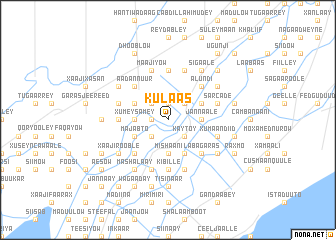
Nearby towns ::
Gariiley (1.9km north) //
Caddiimoole (1.9km west) //
Kaytoy (2.6km south east) //
Gariiley (2.6km north east) //
Cali Xirel (2.6km north west) //
Daanti (2.6km south west) //
Doonka Daafeedow (3.7km south) //
Mishaani (3.7km south) //
Doobis (3.7km east) //
Jannaale (3.7km east) //
Xumey-Samey (3.7km west) //
Maanjoor (3.7km west) //
Baasani Oreste (4.1km south east) //
Babaay (4.1km north east) //
Duurey (4.1km north west) //
Majabto (4.1km south west) //
Buur Fuule (5.2km south east) //
Cusmaan Khamisow (5.2km north east) //
Laba Garas (5.2km south east) //
Alundi (5.2km north east) //
Maʼaero (5.2km north east) //
Kamiiro (5.2km south east) //
Cabdillahi Caddow (5.2km north west) //
Baasani Anjalo (5.2km south west) //
Khaliif (5.2km south west) //
Aadan Nuur (5.2km north west) //
Tawakal (5.6km west) //
Muuse (5.6km west) //
Shalleeday (5.6km north) //
[all distances 'as the bird flies' and approximate] 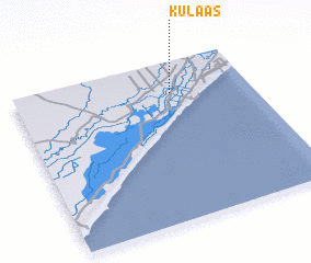 Places with similar names to Kulaas, Somalia ::
Disclaimer :: Information on this page comes without warranty of any kind |
||
|
Where is Kulaas? Elevation and coordinates ::
Latitude (lat): 1°48'0"N Longitude (lon): 44°40'0"E
Elevation (approx.): 70m (map arrows pan, magnifying glasses zoom) |
||
|
Visiting Kulaas? Hotel/Accommodation ::
Book a hotel in Kulaas Travel Guide ::
Buy a travel guide for Somalia rental cars ::
car rental offers GPS waypoint ::
download a GPX waypoint (PoI) of Kulaas for your GPS receiver
|
||