|
search place name
|
||
Manaur (Bay, Somalia)Manaur is a town in the Bay region of Somalia. An overview map of the region around Manaur is displayed below.
regional and 3d topo map of Manaur, Somalia ::
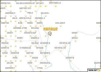
Nearby towns ::
Dheere (1.9km west) //
Gesareeb (4.1km south west) //
Ceel Doon (5.2km north east) //
Gorey (5.2km north west) //
Halule (5.6km west) //
Waranle (5.6km west) //
Kobonle (5.9km west) //
Caadey (5.9km west) //
Aikijedi (5.9km west) //
Mayafulka (6.7km south east) //
Salbuk (6.7km south west) //
Mayafulka (6.7km south east) //
Maroodile (6.7km north west) //
Warabale (6.7km north west) //
Afhuug (6.7km south west) //
Xasno-Yusuf (7.4km west) //
Baydhabo (7.6km south) //
Udgashan (7.6km west) //
Galweel (7.6km north) //
Danbar (7.9km north west) //
Caadey (8.3km south west) //
Nasib (8.3km north west) //
Isha (8.3km north west) //
Dabeylow (9.3km north west) //
Danyar (10.5km south west) //
Yaqle (10.5km north west) //
Gaal Somaal (10.5km north west) //
[all distances 'as the bird flies' and approximate] 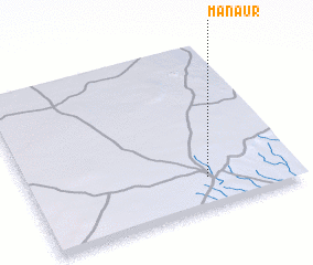 Places with similar names to Manaur, Somalia ::
Disclaimer :: Information on this page comes without warranty of any kind |
||
|
Where is Manaur? Elevation and coordinates ::
Latitude (lat): 3°11'0"N Longitude (lon): 43°40'0"E
Elevation (approx.): 475m (map arrows pan, magnifying glasses zoom) |
||
|
Visiting Manaur? Hotel/Accommodation ::
Book a hotel in Manaur Travel Guide ::
Buy a travel guide for Somalia rental cars ::
car rental offers GPS waypoint ::
download a GPX waypoint (PoI) of Manaur for your GPS receiver
|
||