|
search place name
|
||
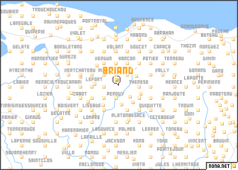
Briand (Ouest, Haiti)Briand is a town in the Ouest region of Haiti. An overview map of the region around Briand is displayed below.
regional and 3d topo map of Briand, Haiti ::
Briand airports ::
The nearest airport is PAP - Port-au-prince Toussaint Louverture Intl, located 66.8 km east of Briand.
Other airports nearby include CAP - Cap Haitien Intl (168.9 km north east), BRX - Barahona Maria Montez Intl (186.3 km east), Nearby towns ::
Dubois (1.6km north) //
Platon Renaud (1.6km north) //
Bellecone (1.6km north) //
Bruand (2.0km north east) //
Depaluce (2.0km north east) //
Perouy (2.2km south) //
Belair (2.2km west) //
Laferranday (2.6km south east) //
Boucan (2.7km north west) //
Clairin (3.0km north east) //
Décidé (3.2km south) //
Parade (3.1km south west) //
Thérese (3.1km east) //
Conotte (3.1km east) //
Beaudry (3.4km north) //
Molière (3.6km south east) //
Marcan (3.6km north) //
Grand Bois (3.6km north) //
Fond Gérard (3.6km south east) //
Lefort (3.6km west) //
Les Palmes (3.7km south east) //
Chavannes (4.0km south west) //
Verdun (4.1km north west) //
Corail (4.1km north west) //
Bayere (4.1km north west) //
Charie (4.0km west) //
Besace (4.2km south) //
Verdies (4.3km west) //
Cadet (4.3km west) //
[all distances 'as the bird flies' and approximate]  Places with similar names to Briand, Haiti ::
Disclaimer :: Information on this page comes without warranty of any kind |
||
|
Where is Briand? Elevation and coordinates ::
Latitude (lat): 18°21'10"N Longitude (lon): 72°52'44"W
Elevation (approx.): 923m (map arrows pan, magnifying glasses zoom) |
||
|
Visiting Briand? Hotel/Accommodation ::
Book a hotel in Briand Travel Guide ::
Buy a travel guide for Haiti rental cars ::
car rental offers GPS waypoint ::
download a GPX waypoint (PoI) of Briand for your GPS receiver
|
||