|
search place name
|
||
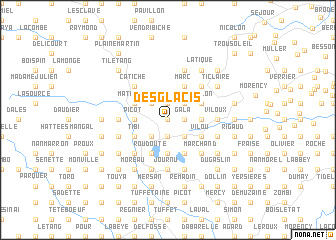
Desglacis (Sud, Haiti)Desglacis is a town in the Sud region of Haiti. An overview map of the region around Desglacis is displayed below.
regional and 3d topo map of Desglacis, Haiti ::
Desglacis airports ::
The nearest airport is PAP - Port-au-prince Toussaint Louverture Intl, located 164.7 km east of Desglacis.
Other airports nearby include CAP - Cap Haitien Intl (230.6 km north east), GAO - Guantanamo Mariana Grajales (237.3 km north west), Nearby towns ::
Trois Rats (0.0km north) //
Boisrond (0.0km north) //
Gala (1.8km east) //
Touarac (1.8km east) //
Mahotière (1.9km north) //
Laroche (1.9km north) //
Saut Mathirine (1.9km north) //
Brouette (1.9km south) //
Matout (1.9km south) //
Vachon (1.9km south) //
Duversin (2.6km north east) //
Étang Dole (2.6km south east) //
Boucher (2.6km south east) //
Ca Durand (2.6km south east) //
Gandou (2.6km north west) //
Guillaume (2.6km north west) //
Bois Rond (2.6km south west) //
Raymond (2.6km south west) //
Mazenod (2.6km south west) //
Joncham (2.6km south west) //
Bourjolly (2.6km south west) //
Sous Byran (3.7km south) //
Souyeau (3.7km south) //
Bouffard (3.5km east) //
Le Pinay (3.5km east) //
Pérény (3.5km west) //
Picot (3.5km west) //
Chaumette (4.1km north east) //
Marc (4.1km north east) //
[all distances 'as the bird flies' and approximate]  Places with similar names to Desglacis, Haiti ::
// Desglacis (HT)
Disclaimer :: Information on this page comes without warranty of any kind |
||
|
Where is Desglacis? Elevation and coordinates ::
Latitude (lat): 18°21'0"N Longitude (lon): 73°50'0"W
Elevation (approx.): 194m (map arrows pan, magnifying glasses zoom) |
||
|
Visiting Desglacis? Hotel/Accommodation ::
Book a hotel in Desglacis Travel Guide ::
Buy a travel guide for Haiti rental cars ::
car rental offers GPS waypoint ::
download a GPX waypoint (PoI) of Desglacis for your GPS receiver
|
||