|
search place name
|
||
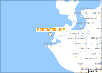
Grande Saline (Artibonite, Haiti)Grande Saline is a town in the Artibonite region of Haiti. An overview map of the region around Grande Saline is displayed below.
regional and 3d topo map of Grande Saline, Haiti ::
Grande Saline airports ::
The nearest airport is CAP - Cap Haitien Intl, located 81.7 km north east of Grande Saline.
Other airports nearby include PAP - Port-au-prince Toussaint Louverture Intl (90.4 km south east), BRX - Barahona Maria Montez Intl (207.3 km south east), IGA - Matthew Town (212.1 km north west), BCA - Baracoa Playa Gustavo Rizo (218.7 km north west), Nearby towns ::
Ravine Sèche (3.7km south) //
Petit Garçon (4.1km south west) //
Dugazon (5.1km south east) //
Dauphin (5.6km east) //
Robinet (7.0km east) //
La Grange (7.2km east) //
Gervet (7.2km east) //
Chauvet (7.2km east) //
[all distances 'as the bird flies' and approximate] 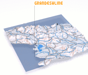 Places with similar names to Grande Saline, Haiti ::
// Grand Saline (US)
// Grande Saline (HT)
// Grande Saline (HT)
// Grande Saline (HT)
// Grand Aslon (FR)
Disclaimer :: Information on this page comes without warranty of any kind |
||
|
Where is Grande Saline? Elevation and coordinates ::
Latitude (lat): 19°15'0"N Longitude (lon): 72°47'0"W
Elevation (approx.): -32768m (map arrows pan, magnifying glasses zoom) |
||
|
Visiting Grande Saline? Hotel/Accommodation ::
Book a hotel in Grande Saline Travel Guide ::
Buy a travel guide for Haiti rental cars ::
car rental offers GPS waypoint ::
download a GPX waypoint (PoI) of Grande Saline for your GPS receiver
|
||