|
search place name
|
||
Mantenoir (Ouest, Haiti)Mantenoir is a town in the Ouest region of Haiti. An overview map of the region around Mantenoir is displayed below.
regional and 3d topo map of Mantenoir, Haiti ::

Mantenoir airports ::
The nearest airport is PAP - Port-au-prince Toussaint Louverture Intl, located 75.2 km east of Mantenoir.
Other airports nearby include CAP - Cap Haitien Intl (131.3 km north east), BRX - Barahona Maria Montez Intl (204.2 km east), BCA - Baracoa Playa Gustavo Rizo (236.9 km north west), MOA - Moa Orestes Acosta (290.1 km north west), Nearby towns ::
Mapou (0.0km north) //
Derrière Marc (1.8km west) //
Mare Terre Noire (1.8km east) //
Plaine des Mapous (1.9km south) //
Nan Café (2.1km north west) //
Grande Source (2.5km north) //
Mare Sucrin (2.5km east) //
Bois Brûlé (2.6km north west) //
LʼAutre Bord de lʼEau (2.6km north west) //
Domicile (2.6km south west) //
Nan Bois de Chêne (2.6km north east) //
Nan Risque (3.7km north) //
Ravine Palmiste (3.7km north) //
Trou Pélé (4.1km north west) //
Morne La Pierre (4.1km south west) //
Dados (4.0km north west) //
Lottore (4.0km south west) //
Bois Pin (4.1km south east) //
Grand Mapou (4.0km south east) //
Herbe Guinée (4.2km north) //
Petite (4.3km north east) //
Nan Canne (4.8km south) //
Nan Lavaud (4.9km north west) //
Platon (5.1km north east) //
Terre Blanche (5.1km north east) //
Source (5.0km north east) //
Terre Rouge (5.3km west) //
Dielgo (5.3km west) //
Bois Pin (5.3km west) //
[all distances 'as the bird flies' and approximate] 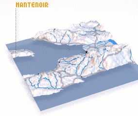 Places with similar names to Mantenoir, Haiti ::
Disclaimer :: Information on this page comes without warranty of any kind |
||
|
Where is Mantenoir? Elevation and coordinates ::
Latitude (lat): 18°48'0"N Longitude (lon): 72°58'0"W
Elevation (approx.): 548m (map arrows pan, magnifying glasses zoom) |
||
|
Visiting Mantenoir? Hotel/Accommodation ::
Book a hotel in Mantenoir Travel Guide ::
Buy a travel guide for Haiti rental cars ::
car rental offers GPS waypoint ::
download a GPX waypoint (PoI) of Mantenoir for your GPS receiver
|
||