|
search place name
|
||
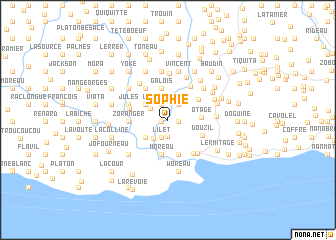
Sophie (Sud-Est, Haiti)Sophie is a town in the Sud-Est region of Haiti. An overview map of the region around Sophie is displayed below.
regional and 3d topo map of Sophie, Haiti ::
Sophie airports ::
The nearest airport is PAP - Port-au-prince Toussaint Louverture Intl, located 65.0 km north east of Sophie.
Other airports nearby include BRX - Barahona Maria Montez Intl (175.2 km east), CAP - Cap Haitien Intl (178.5 km north), Nearby towns ::
La Petite Plaine (0.7km west) //
Ca Cola (0.7km west) //
Dupuy (1.1km east) //
LʼHermitage (1.8km north) //
Desnoyers (1.8km north) //
Pradine (1.9km south) //
Gascon (2.0km north east) //
Longois (2.0km north east) //
Barreau (2.0km north east) //
LʼÎlet (2.1km south) //
Bellevue (2.1km south) //
Gori (2.3km north west) //
Gori (2.6km south west) //
Marie Thérèse (3.0km north west) //
Corail (3.2km south west) //
Benoît (3.2km south west) //
Darapin (3.2km south west) //
Bourgouin (3.6km north) //
Galois (3.6km north) //
Otage (3.6km east) //
Moreau (3.9km south) //
Coicou (3.9km south) //
Baptiste (4.0km south) //
Martino (3.9km north east) //
Douzil (4.1km south east) //
Funel (4.3km north west) //
Bernaleau (4.3km north west) //
Zoranger (4.2km west) //
Ca Laneau (4.4km north east) //
[all distances 'as the bird flies' and approximate]  Places with similar names to Sophie, Haiti ::
Disclaimer :: Information on this page comes without warranty of any kind |
||
|
Where is Sophie? Elevation and coordinates ::
Latitude (lat): 18°13'5"N Longitude (lon): 72°46'37"W
Elevation (approx.): 220m (map arrows pan, magnifying glasses zoom) |
||
|
Visiting Sophie? Hotel/Accommodation ::
Book a hotel in Sophie Travel Guide ::
Buy a travel guide for Haiti rental cars ::
car rental offers GPS waypoint ::
download a GPX waypoint (PoI) of Sophie for your GPS receiver
|
||