|
search place name
|
||
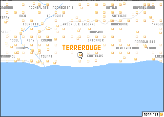
Terre Rouge (Sud-Est, Haiti)Terre Rouge is a town in the Sud-Est region of Haiti. An overview map of the region around Terre Rouge is displayed below.
regional and 3d topo map of Terre Rouge, Haiti ::
Terre Rouge airports ::
The nearest airport is PAP - Port-au-prince Toussaint Louverture Intl, located 38.7 km north of Terre Rouge.
Other airports nearby include BRX - Barahona Maria Montez Intl (115.5 km east), CAP - Cap Haitien Intl (165.4 km north), STI - Santiago Cibao Intl (213.1 km north east), POP - Puerto Plata Gregorio Luperon Intl (241.2 km north east), Nearby towns ::
Adieu au Monde (0.8km south west) //
Cacoli (1.3km north) //
Ravine Cajou (1.5km south east) //
Herbe Guinée (1.8km north east) //
Yombe (1.8km north east) //
Nan Noël (2.4km north) //
Bordes (2.5km north west) //
Trou Mahot (2.5km north west) //
Jimoun (2.5km north west) //
Voutoson (2.5km north west) //
Plaisir (3.1km north) //
Coutelas (3.1km east) //
Bossuet (3.4km north east) //
Baptiste (3.4km north east) //
Bassin Pian (3.3km east) //
Respect (3.8km north west) //
Boulaille (3.8km north west) //
Satorfer (4.4km north east) //
Bois de Lenthel (4.4km north east) //
Nan Plaisir (4.4km north east) //
Baie dʼOrange (4.6km north) //
Dubois (5.0km north) //
Bois Pin (5.1km north) //
Grand Bois (5.1km north) //
Gros Bois (5.0km north west) //
La Garde (5.0km north west) //
La Source (5.4km north west) //
Ti Bois Pin (5.8km north east) //
Mare Plate (5.8km north east) //
[all distances 'as the bird flies' and approximate]  Places with similar names to Terre Rouge, Haiti ::
// Dry Ridge (US)
// Dry Ridge (US)
// Driorejo (ID)
// Terre Rouge (GF)
// Terre Rouge (GF)
// Terre Rouge (HT)
// Terre Rouge (HT)
// Terre Rouge (HT)
// Terre Rouge (HT)
// Terre Rouge (HT)
Disclaimer :: Information on this page comes without warranty of any kind |
||
|
Where is Terre Rouge? Elevation and coordinates ::
Latitude (lat): 18°14'20"N Longitude (lon): 72°12'45"W
Elevation (approx.): 516m (map arrows pan, magnifying glasses zoom) |
||
|
Visiting Terre Rouge? Hotel/Accommodation ::
Book a hotel in Terre Rouge Travel Guide ::
Buy a travel guide for Haiti rental cars ::
car rental offers GPS waypoint ::
download a GPX waypoint (PoI) of Terre Rouge for your GPS receiver
|
||