|
search place name
|
||
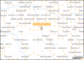
Kandegama (Sabaragamuwa, Sri Lanka)Kandegama is a town in the Sabaragamuwa region of Sri Lanka. An overview map of the region around Kandegama is displayed below.
regional and 3d topo map of Kandegama, Sri Lanka ::
Kandegama airports ::
The nearest airport is RML - Colombo Ratmalana, located 52.0 km north west of Kandegama.
Other airports nearby include CMB - Bandaranaike Intl Colombo (77.1 km north west), GOY - Galoya Amparai (164.3 km north east), TRR - Trinciomalee China Bay (231.3 km north east), Nearby towns ::
Ereporuwa (0.0km north) //
Ayagama (1.1km north west) //
Watteinnekanda (1.8km west) //
Batakada (2.6km north east) //
Paragahahena (2.6km north east) //
Ellehena (2.6km north west) //
Ukkettekanda (2.6km north west) //
Indolewatta (2.6km north west) //
Pareyigalekanda (3.7km east) //
Alupatgala (3.7km north) //
Patagama (3.7km north) //
Mawarakanda (3.7km west) //
Gallenakanda (4.1km south east) //
Paragala (4.1km south east) //
Handunkanda (4.1km south east) //
Udugala (4.1km south east) //
Palawela (4.1km north east) //
Damme (4.1km north east) //
Gendagala (4.1km south west) //
Patagama (4.1km north east) //
Weragama (4.1km north east) //
Kalatuwakanda (4.1km north west) //
Kankanikanda (4.1km north west) //
Pallekada (4.1km north west) //
Gulanekanda (4.1km north west) //
Galaudakanda (5.2km south east) //
Dellaboda (5.2km north east) //
Watakurugala (5.2km north west) //
Gangodakanda (5.2km north west) //
[all distances 'as the bird flies' and approximate]  Places with similar names to Kandegama, Sri Lanka ::
// Candigum (PH)
// Canduao Gamay (PH)
// Canticum (PH)
// Gounou Dogom (TD)
// Kandegama (LK)
// Kandegama (LK)
// Kandegama (LK)
// Kandegama (LK)
// Kandegama (LK)
// Kandegama (LK)
Disclaimer :: Information on this page comes without warranty of any kind |
||
|
Where is Kandegama? Elevation and coordinates ::
Latitude (lat): 6°38'0"N Longitude (lon): 80°19'0"E
Elevation (approx.): 109m (map arrows pan, magnifying glasses zoom) |
||
|
Visiting Kandegama? Hotel/Accommodation ::
Book a hotel in Kandegama Travel Guide ::
Buy a travel guide for Sri Lanka rental cars ::
car rental offers GPS waypoint ::
download a GPX waypoint (PoI) of Kandegama for your GPS receiver
|
||