|
search place name
|
||
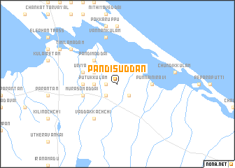
Pandisuddan (North Eastern, Sri Lanka)Pandisuddan is a town in the North Eastern region of Sri Lanka. An overview map of the region around Pandisuddan is displayed below.
regional and 3d topo map of Pandisuddan, Sri Lanka ::
Pandisuddan airports ::
The nearest airport is JAF - Jaffna Kankesanturai, located 60.5 km north west of Pandisuddan.
Other airports nearby include TRR - Trinciomalee China Bay (125.6 km south east), TRZ - Tiruchchirappalli Tiruchirappalli (244.3 km north west), Nearby towns ::
Kandavalai (1.8km west) //
Velikkandal (2.6km south west) //
Puliyampokkanai (2.6km south east) //
Putukkulam (3.7km west) //
Pulinkatevanmurippu (3.7km west) //
Udupattukkandal (3.7km west) //
Upparu (4.1km north west) //
Pandimoddai (5.2km north west) //
Punnainiravi (5.5km east) //
Korakkankaddu (5.5km west) //
Kalavedditidal (5.5km east) //
Murasumoddai (5.8km west) //
Uriyan (5.8km west) //
Vaddakkachchi (6.7km south west) //
Vannankulam (7.6km north) //
Timilamadam (9.2km north west) //
[all distances 'as the bird flies' and approximate]  Places with similar names to Pandisuddan, Sri Lanka :: Disclaimer :: Information on this page comes without warranty of any kind |
||
|
Where is Pandisuddan? Elevation and coordinates ::
Latitude (lat): 9°27'0"N Longitude (lon): 80°30'0"E
Elevation (approx.): 8m (map arrows pan, magnifying glasses zoom) |
||
|
Visiting Pandisuddan? Hotel/Accommodation ::
Book a hotel in Pandisuddan Travel Guide ::
Buy a travel guide for Sri Lanka rental cars ::
car rental offers GPS waypoint ::
download a GPX waypoint (PoI) of Pandisuddan for your GPS receiver
|
||