|
search place name
|
||
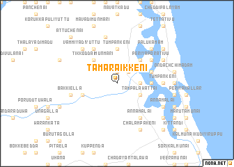
Tamaraikkeni (North Eastern, Sri Lanka)Tamaraikkeni is a town in the North Eastern region of Sri Lanka. An overview map of the region around Tamaraikkeni is displayed below.
regional and 3d topo map of Tamaraikkeni, Sri Lanka ::
Tamaraikkeni airports ::
The nearest airport is GOY - Galoya Amparai, located 19.0 km south west of Tamaraikkeni.
Other airports nearby include TRR - Trinciomalee China Bay (130.7 km north west), CMB - Bandaranaike Intl Colombo (205.1 km west), RML - Colombo Ratmalana (215.0 km west), Nearby towns ::
Valaichchenai (1.9km north) //
Vellaveli (2.6km north east) //
Mandur (3.7km east) //
Palamunai (3.7km east) //
Tampalawattai (4.1km south east) //
Kovilporativu (5.2km north east) //
Munaittivu (5.2km north east) //
Tikkoddaimunmari (5.2km north west) //
Mandukkoddaimunai (5.5km east) //
Kurumunveli (5.5km east) //
Tumpankeni (5.6km north) //
Aliyarvaddai (5.8km west) //
Kodaimedu (5.8km east) //
Annamalai (6.7km south east) //
Periyaporativu (6.6km north east) //
Tikkottaimadu (6.7km north west) //
Tikkodai (6.7km north west) //
Tumpankeni (7.4km east) //
Bakkiella (7.6km west) //
Kalumantanveli (7.6km north) //
Palukamam (7.8km north east) //
Vammiyadiyuttu (7.8km north west) //
Annamalai (8.2km south east) //
Chalampakeni (8.3km south east) //
Paddiruppu (8.2km north east) //
Kaluvanchikudiyiruppu (8.2km north east) //
Navithanveli (9.2km south east) //
Kalutavalai (9.2km north east) //
Charalakadai (10.4km south east) //
[all distances 'as the bird flies' and approximate]  Places with similar names to Tamaraikkeni, Sri Lanka ::
Disclaimer :: Information on this page comes without warranty of any kind |
||
|
Where is Tamaraikkeni? Elevation and coordinates ::
Latitude (lat): 7°29'0"N Longitude (lon): 81°43'0"E
Elevation (approx.): 12m (map arrows pan, magnifying glasses zoom) |
||
|
Visiting Tamaraikkeni? Hotel/Accommodation ::
Book a hotel in Tamaraikkeni Travel Guide ::
Buy a travel guide for Sri Lanka rental cars ::
car rental offers GPS waypoint ::
download a GPX waypoint (PoI) of Tamaraikkeni for your GPS receiver
|
||