|
search place name
|
||
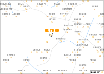
Butebe (Busoga, Uganda)Butebe is a town in the Busoga region of Uganda. An overview map of the region around Butebe is displayed below.
regional and 3d topo map of Butebe, Uganda ::
Butebe airports ::
The nearest airport is EBB - Entebbe Intl, located 61.5 km south east of Butebe.
Other airports nearby include SRT - Soroti (237.7 km north east), BUX - Bunia (237.8 km north west), Nearby towns ::
Kalyankoko (2.6km south west) //
Nakibanga (3.5km south east) //
Katiko (5.6km north) //
Misigi (5.9km south) //
Nambale (5.9km east) //
Namukozi (6.7km north east) //
Kimuli (6.7km south west) //
Naama (7.4km north) //
Busundo (7.6km north) //
Lubaja (7.9km south west) //
Mityana (8.7km north east) //
Maanyi (9.1km south) //
Kyandalo (9.3km south west) //
Kande (9.3km south east) //
Bukola (9.3km south east) //
[all distances 'as the bird flies' and approximate] 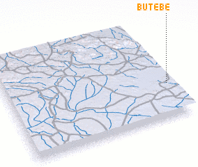 Places with similar names to Butebe, Uganda ::
Disclaimer :: Information on this page comes without warranty of any kind |
||
|
Where is Butebe? Elevation and coordinates ::
Latitude (lat): 0°21'0"S Longitude (lon): 31°59'0"E
Elevation (approx.): 1166m (map arrows pan, magnifying glasses zoom) |
||
|
Visiting Butebe? Hotel/Accommodation ::
Book a hotel in Butebe Travel Guide ::
Buy a travel guide for Uganda rental cars ::
car rental offers GPS waypoint ::
download a GPX waypoint (PoI) of Butebe for your GPS receiver
|
||