|
search place name
|
||
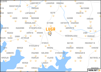
Luga (Busoga, Uganda)Luga is a town in the Busoga region of Uganda. An overview map of the region around Luga is displayed below.
regional and 3d topo map of Luga, Uganda ::
Luga airports ::
The nearest airport is EBB - Entebbe Intl, located 49.1 km south west of Luga.
Other airports nearby include SRT - Soroti (185.5 km north east), KIS - Kisumu (214.3 km east), Nearby towns ::
Banda (1.9km north) //
Nagunga (3.5km south) //
Kitebe (3.7km north) //
Mpoma (3.7km west) //
Ntanzi (4.1km south west) //
Katente (4.1km north east) //
Mpumu (5.6km south) //
Ntakafunvu (5.9km west) //
Katente (6.7km north east) //
Nakisunga (7.2km north west) //
Kipayo (7.4km west) //
Seta (7.6km north) //
Salama (7.6km south) //
Wankata (7.6km east) //
Ntenjeru (7.7km south west) //
Namaiba (7.9km north west) //
Nkokonjeru (7.9km east) //
Mangaliba (8.3km north west) //
Buyiri (8.3km south east) //
Kyesimira (8.3km south east) //
Nsumba (9.3km south west) //
Nsonga (9.3km south east) //
Busabaga (9.3km north east) //
Vumba (9.3km north east) //
Kibanga Port (9.5km south east) //
Lofumvwe (10.5km north west) //
[all distances 'as the bird flies' and approximate]  Places with similar names to Luga, Uganda ::
Disclaimer :: Information on this page comes without warranty of any kind |
||
|
Where is Luga? Elevation and coordinates ::
Latitude (lat): 0°15'0"S Longitude (lon): 32°50'0"E
Elevation (approx.): 1178m (map arrows pan, magnifying glasses zoom) |
||
|
Visiting Luga? Hotel/Accommodation ::
Book a hotel in Luga Travel Guide ::
Buy a travel guide for Uganda rental cars ::
car rental offers GPS waypoint ::
download a GPX waypoint (PoI) of Luga for your GPS receiver
|
||