|
search place name
|
||
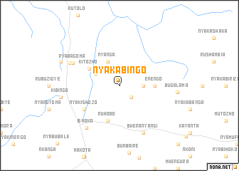
Nyakabingo (Busoga, Uganda)Nyakabingo is a town in the Busoga region of Uganda. An overview map of the region around Nyakabingo is displayed below.
regional and 3d topo map of Nyakabingo, Uganda ::
Nyakabingo airports ::
The nearest airport is KGL - Kigali Intl, located 164.3 km south of Nyakabingo.
Other airports nearby include GYI - Gisenyi (167.4 km south west), GOM - Goma (168.2 km south west), BKY - Bukavu/kavumu Bukavu Kavumu (253.3 km south west), KME - Kamembe (260.8 km south west), Nearby towns ::
Kakanzhu (2.6km south east) //
Ekininga (3.7km east) //
Nyanga (4.1km north west) //
Kyamumali (4.1km north west) //
Kitozho (5.4km north west) //
Enengo (5.6km east) //
Ruhobo (5.9km south) //
Nyakishozo (6.7km south west) //
Ryabagoma (8.1km north west) //
Bweranyangi (8.3km south east) //
Ishaka (8.4km south west) //
Kyamahungu (8.6km north west) //
[all distances 'as the bird flies' and approximate]  Places with similar names to Nyakabingo, Uganda ::
// Nyakabingo (BI)
// Nyakabanga (UG)
// Nyakabingo (UG)
// Nyakabingo (UG)
// Nyakabungo (UG)
// Nyakabungo (UG)
// Nyakabungo (UG)
// Nyakabungo (UG)
// Nyakibingo (UG)
// Nyakabongo (RW)
Disclaimer :: Information on this page comes without warranty of any kind |
||
|
Where is Nyakabingo? Elevation and coordinates ::
Latitude (lat): 0°29'0"S Longitude (lon): 30°11'0"E
Elevation (approx.): 1610m (map arrows pan, magnifying glasses zoom) |
||
|
Visiting Nyakabingo? Hotel/Accommodation ::
Book a hotel in Nyakabingo Travel Guide ::
Buy a travel guide for Uganda rental cars ::
car rental offers GPS waypoint ::
download a GPX waypoint (PoI) of Nyakabingo for your GPS receiver
|
||