|
search place name
|
||
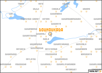
Doumoukada (Zinder, Niger)Doumoukada is a town in the Zinder region of Niger. An overview map of the region around Doumoukada is displayed below.
regional and 3d topo map of Doumoukada, Niger ::
Doumoukada airports ::
The nearest airport is ZND - Zinder, located 132.5 km south east of Doumoukada.
Other airports nearby include MFG - Maradi (147.8 km south west), Nearby towns ::
Zangon Moussa (1.8km west) //
Guidan Bouda (2.6km north east) //
Guidan Aloumou (2.6km north west) //
Mwala (2.6km south west) //
Guidan Ali (3.6km west) //
Guidan Iya (4.1km north east) //
Guidan Chadawa (5.2km south east) //
I-n-Ouala (5.6km north) //
May Kyérawa (5.6km south) //
Guidan Maroki (5.8km south) //
Kataré (5.8km north) //
I-n-Gouitou (6.6km south east) //
Guidan Ibra (6.5km north east) //
Doumankada (6.5km south west) //
Aékao (6.6km north west) //
Sérkin Aréwa (7.2km south west) //
Rougoumnia (7.4km south) //
Guidan Bako (7.6km north) //
Guidan Bango (7.4km west) //
Gaomey (7.7km north west) //
Guidan Toukou (7.7km west) //
Guidan Moussa (8.1km south east) //
May Dawa (8.2km south east) //
Gobérawa (9.1km south east) //
Guidan Oubandawaki (9.1km north east) //
[all distances 'as the bird flies' and approximate] 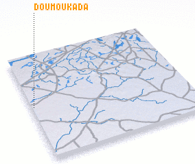 Places with similar names to Doumoukada, Niger ::
Disclaimer :: Information on this page comes without warranty of any kind |
||
|
Where is Doumoukada? Elevation and coordinates ::
Latitude (lat): 14°31'0"N Longitude (lon): 8°1'0"E
Elevation (approx.): 423m (map arrows pan, magnifying glasses zoom) |
||
|
Visiting Doumoukada? Hotel/Accommodation ::
Book a hotel in Doumoukada Travel Guide ::
Buy a travel guide for Niger rental cars ::
car rental offers GPS waypoint ::
download a GPX waypoint (PoI) of Doumoukada for your GPS receiver
|
||