|
search place name
|
||
Batinba (Tambacounda, Senegal)Batinba is a town in the Tambacounda region of Senegal. An overview map of the region around Batinba is displayed below.
regional and 3d topo map of Batinba, Senegal ::

Batinba airports ::
The nearest airport is KGG - Kedougou, located 37.2 km east of Batinba.
Other airports nearby include LEK - Labe (131.2 km south), TUD - Tambacounda (183.1 km north west), KYS - Kayes Dag Dag (253.5 km north east), Nearby towns ::
Louguéniani (1.9km south) //
Négodié (3.6km west) //
Saamouka (4.1km south west) //
Diougol Diara (5.4km west) //
Doubel Badiel (5.7km west) //
Hamdalaye (5.7km east) //
Koumafélé (5.7km east) //
Sila Kounda (5.8km south) //
Kadioré (6.6km south east) //
Lagordé (7.6km south) //
Salaya (7.5km east) //
Gounbabéré (8.2km south east) //
Outioumbel (9.1km south west) //
Sanigourou (10.4km south east) //
[all distances 'as the bird flies' and approximate] 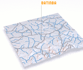 Places with similar names to Batinba, Senegal ::
Disclaimer :: Information on this page comes without warranty of any kind |
||
|
Where is Batinba? Elevation and coordinates ::
Latitude (lat): 12°29'0"N Longitude (lon): 12°33'0"W
Elevation (approx.): 90m (map arrows pan, magnifying glasses zoom) |
||
|
Visiting Batinba? Hotel/Accommodation ::
Book a hotel in Batinba Travel Guide ::
Buy a travel guide for Senegal rental cars ::
car rental offers GPS waypoint ::
download a GPX waypoint (PoI) of Batinba for your GPS receiver
|
||