|
search place name
|
||
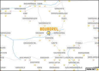
Bouborel (Kolda, Senegal)Bouborel is a town in the Kolda region of Senegal. An overview map of the region around Bouborel is displayed below.
regional and 3d topo map of Bouborel, Senegal ::
Bouborel airports ::
The nearest airport is TUD - Tambacounda, located 142.4 km north east of Bouborel.
Other airports nearby include BXO - Bissau Oswaldo Vieira Intl (156.8 km south west), ZIG - Ziguinchor (193.2 km west), KLC - Kaolack (225.7 km north west), Nearby towns ::
Tiarap (1.9km north) //
Niéniéné (1.9km south) //
Koudora (3.6km west) //
Kanikoro (3.6km east) //
Saré Kémadi (3.6km east) //
Saré Karfa (3.6km east) //
Sansankoto (4.1km north west) //
Banbadinnka (4.1km south west) //
Saré Abdoulaye (4.1km north east) //
Dibito (4.1km south east) //
Niandinndia Dimbel (6.6km south east) //
Ngoki (7.8km north east) //
Mérévé (7.8km south east) //
Koudoureyel (8.1km south west) //
Saré Ndiaba Djidé (8.2km north east) //
Koumbakara (8.2km south east) //
Saré Samba Iopé (9.1km north west) //
Moki (9.2km north east) //
[all distances 'as the bird flies' and approximate] 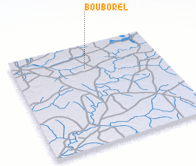 Places with similar names to Bouborel, Senegal ::
Disclaimer :: Information on this page comes without warranty of any kind |
||
|
Where is Bouborel? Elevation and coordinates ::
Latitude (lat): 12°46'0"N Longitude (lon): 14°31'0"W
Elevation (approx.): 34m (map arrows pan, magnifying glasses zoom) |
||
|
Visiting Bouborel? Hotel/Accommodation ::
Book a hotel in Bouborel Travel Guide ::
Buy a travel guide for Senegal rental cars ::
car rental offers GPS waypoint ::
download a GPX waypoint (PoI) of Bouborel for your GPS receiver
|
||