|
search place name
|
||
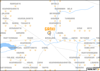
Ganki (Kaolack, Senegal)Ganki is a town in the Kaolack region of Senegal. An overview map of the region around Ganki is displayed below.
regional and 3d topo map of Ganki, Senegal ::
Ganki airports ::
The nearest airport is KLC - Kaolack, located 32.5 km west of Ganki.
Other airports nearby include BJL - Banjul Intl (132.6 km south west), ZIG - Ziguinchor (185.6 km south), DKR - Dakar Leopold Sedar Senghor Intl (198.7 km west), CSK - Cap Skiring (220.7 km south west), Nearby towns ::
Darou Salam (1.9km north) //
Birkelane (1.9km south) //
Lougol (3.6km east) //
Keur Magaye (4.1km north east) //
Band (4.0km south east) //
Diamaguène (5.2km north east) //
Keur Baye Diop (5.2km north east) //
Fas (5.4km east) //
Dioundia (5.8km north) //
Diamal (5.8km south) //
Korki (5.7km east) //
Bidiam (6.6km north east) //
Bayandour (7.6km north) //
Nguer (7.4km west) //
Diassoum (7.4km east) //
Dangane (7.7km south west) //
Ganbou (8.1km north west) //
Tivaouane (9.1km north east) //
Livé (9.1km north east) //
Guennté Boye (9.1km south west) //
[all distances 'as the bird flies' and approximate]  Places with similar names to Ganki, Senegal ::
Disclaimer :: Information on this page comes without warranty of any kind |
||
|
Where is Ganki? Elevation and coordinates ::
Latitude (lat): 14°9'0"N Longitude (lon): 15°45'0"W
Elevation (approx.): 10m (map arrows pan, magnifying glasses zoom) |
||
|
Visiting Ganki? Hotel/Accommodation ::
Book a hotel in Ganki Travel Guide ::
Buy a travel guide for Senegal rental cars ::
car rental offers GPS waypoint ::
download a GPX waypoint (PoI) of Ganki for your GPS receiver
|
||