|
search place name
|
||
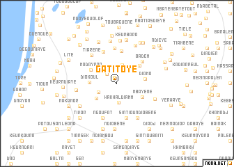
Gati Toye (Louga, Senegal)Gati Toye is a town in the Louga region of Senegal. An overview map of the region around Gati Toye is displayed below.
regional and 3d topo map of Gati Toye, Senegal ::
Gati Toye airports ::
The nearest airport is XLS - St. Louis Saint Louis, located 30.5 km north of Gati Toye.
Other airports nearby include DKR - Dakar Leopold Sedar Senghor Intl (164.7 km south west), KLC - Kaolack (184.8 km south), Nearby towns ::
Maka Taré (2.1km north west) //
Wakhal Diamm (3.1km south) //
Deuk Bouréy (3.1km north) //
Ndiallakhâr (3.2km south west) //
Ndiayène (4.0km south west) //
Diokoul (4.3km west) //
Mbayène (4.4km south east) //
Diama (4.4km east) //
Kère Ndiaye (4.6km north east) //
Madayana (4.6km north west) //
Amat Ba (5.2km north) //
Badèm Ouolof (5.3km north east) //
Badèm (5.3km north east) //
Tiélémane (5.5km north) //
Mbaye Mbaye (5.6km north) //
Diadj (5.7km south) //
Ngoufat (5.9km south) //
Tiarène (6.0km north west) //
Sintiou Ndiobène (6.4km south east) //
Ouakhal (6.4km south east) //
Keur Mafal (6.3km south east) //
Keur Mandiol (6.4km west) //
Khelkom Diaw (6.7km north east) //
Rakhmane (6.8km north) //
Rakhmane Sal (6.9km north) //
Bayakh (6.8km south west) //
Keur Bara (7.1km north) //
Tiar Moussé Diop (7.2km north west) //
Ndiobène (7.4km south) //
[all distances 'as the bird flies' and approximate]  Places with similar names to Gati Toye, Senegal ::
Disclaimer :: Information on this page comes without warranty of any kind |
||
|
Where is Gati Toye? Elevation and coordinates ::
Latitude (lat): 15°46'58"N Longitude (lon): 16°23'47"W
Elevation (approx.): 22m (map arrows pan, magnifying glasses zoom) |
||
|
Visiting Gati Toye? Hotel/Accommodation ::
Book a hotel in Gati Toye Travel Guide ::
Buy a travel guide for Senegal rental cars ::
car rental offers GPS waypoint ::
download a GPX waypoint (PoI) of Gati Toye for your GPS receiver
|
||