|
search place name
|
||
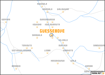
Guéssébové (Tambacounda, Senegal)Guéssébové is a town in the Tambacounda region of Senegal. An overview map of the region around Guéssébové is displayed below.
regional and 3d topo map of Guéssébové, Senegal ::
Guéssébové airports ::
The nearest airport is KGG - Kedougou, located 115.5 km south of Guéssébové.
Other airports nearby include KYS - Kayes Dag Dag (118.8 km north east), BXE - Bakel (145.8 km north), SEY - Selibabi Selibady (175.8 km north), TUD - Tambacounda (175.9 km west), Nearby towns ::
Lamina (0.0km north) //
Dabaya (1.8km east) //
Kaourou (2.6km north west) //
Kouladiansita (3.7km north) //
Yelimalo (4.1km south east) //
Ouayaga (5.2km south east) //
Kodiadian (5.2km south east) //
Samadala (5.4km west) //
Bountou (5.6km north) //
Léoba (5.8km south) //
Ouassa Ouassa (5.8km north) //
Koukoma (6.6km north west) //
Niénoko (7.8km south east) //
Kobokoto (7.8km south east) //
Konkoto (7.8km north west) //
Sandikouba (8.1km south west) //
[all distances 'as the bird flies' and approximate] 
Disclaimer :: Information on this page comes without warranty of any kind |
||
|
Where is Guéssébové? Elevation and coordinates ::
Latitude (lat): 13°36'0"N Longitude (lon): 12°2'0"W
Elevation (approx.): 74m (map arrows pan, magnifying glasses zoom) |
||
|
Visiting Guéssébové? Hotel/Accommodation ::
Book a hotel in Guéssébové Travel Guide ::
Buy a travel guide for Senegal rental cars ::
car rental offers GPS waypoint ::
download a GPX waypoint (PoI) of Guéssébové for your GPS receiver
|
||