|
search place name
|
||
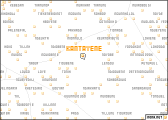
Kantayène (Louga, Senegal)Kantayène is a town in the Louga region of Senegal. An overview map of the region around Kantayène is displayed below.
regional and 3d topo map of Kantayène, Senegal ::
Kantayène airports ::
The nearest airport is XLS - St. Louis Saint Louis, located 59.0 km north west of Kantayène.
Other airports nearby include KLC - Kaolack (166.4 km south), DKR - Dakar Leopold Sedar Senghor Intl (180.2 km south west), Nearby towns ::
Tako (2.6km south west) //
Niomré Lo (4.1km north west) //
Tioubène (4.0km south west) //
Tanim (5.1km south west) //
Nayobé (5.4km east) //
Ndam Khalil (5.7km west) //
Ndiobène (5.7km west) //
Pakhaso (5.8km north) //
Lemdou (5.7km east) //
Ndam Khab (6.6km north west) //
Keur Ibra Maram (6.6km south west) //
Keur Médoune Mbaye (6.5km north east) //
Keur Mor Bèye (6.5km north east) //
Sakal (6.6km south east) //
Nguiobène (7.1km west) //
Dogol (7.4km south) //
Keur Dam (7.6km south) //
Ndam (7.6km south) //
Ndiakhaté (7.6km south) //
Keur Modou (7.4km east) //
Keur Madialé (7.7km north east) //
Danko (8.0km south west) //
Gouye Mbeut (8.0km north east) //
Ndiaouène (8.0km south east) //
Diakhaslène (9.1km north west) //
Gouyar (9.1km south west) //
Gati Pakha (9.1km north east) //
Keur Siné (9.0km south west) //
Tiomadé (9.0km north east) //
[all distances 'as the bird flies' and approximate]  Places with similar names to Kantayène, Senegal ::
Disclaimer :: Information on this page comes without warranty of any kind |
||
|
Where is Kantayène? Elevation and coordinates ::
Latitude (lat): 15°39'0"N Longitude (lon): 16°6'0"W
Elevation (approx.): 36m (map arrows pan, magnifying glasses zoom) |
||
|
Visiting Kantayène? Hotel/Accommodation ::
Book a hotel in Kantayène Travel Guide ::
Buy a travel guide for Senegal rental cars ::
car rental offers GPS waypoint ::
download a GPX waypoint (PoI) of Kantayène for your GPS receiver
|
||