|
search place name
|
||
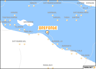
Oréfondé (Saint-Louis, Senegal)Oréfondé is a town in the Saint-Louis region of Senegal. An overview map of the region around Oréfondé is displayed below.
regional and 3d topo map of Oréfondé, Senegal ::
Oréfondé airports ::
The nearest airport is KED - Kaedi, located 27.0 km north east of Oréfondé.
Other airports nearby include SEY - Selibabi Selibady (189.9 km south east), BXE - Bakel (190.1 km south east), Nearby towns ::
Diaba (1.9km south) //
Diaba Déguélé (3.6km west) //
Aïné Bala (4.1km south east) //
Diaba Mondi (4.0km north west) //
Ndiaker (5.1km south east) //
Ouro Mollo (5.1km south east) //
Dioguel (6.6km north east) //
Mbolo Ali (7.1km west) //
Diorbiwol (7.6km north) //
Goli (7.7km south east) //
Lidoubé (7.7km south east) //
Dirimbodia (8.0km north west) //
Ouro Soré (9.0km south east) //
Tiaski (9.0km north east) //
[all distances 'as the bird flies' and approximate] 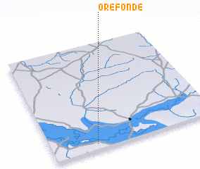 Places with similar names to Oréfondé, Senegal ::
// Ouro Vèndou (SN)
// Oré Vendou (GN)
// Orévenndou (GN)
// Orévenndou (GN)
// Oré Vindou (GN)
// Oré Vendou (ML)
// Ouro Viendou (CM)
Disclaimer :: Information on this page comes without warranty of any kind |
||
|
Where is Oréfondé? Elevation and coordinates ::
Latitude (lat): 16°3'0"N Longitude (lon): 13°44'0"W
Elevation (approx.): 14m (map arrows pan, magnifying glasses zoom) |
||
|
Visiting Oréfondé? Hotel/Accommodation ::
Book a hotel in Oréfondé Travel Guide ::
Buy a travel guide for Senegal rental cars ::
car rental offers GPS waypoint ::
download a GPX waypoint (PoI) of Oréfondé for your GPS receiver
|
||