|
search place name
|
||
Polam Rok (Thiès, Senegal)Polam Rok is a town in the Thiès region of Senegal. An overview map of the region around Polam Rok is displayed below.
regional and 3d topo map of Polam Rok, Senegal ::

Polam Rok airports ::
The nearest airport is DKR - Dakar Leopold Sedar Senghor Intl, located 62.9 km west of Polam Rok.
Other airports nearby include KLC - Kaolack (107.7 km south east), BJL - Banjul Intl (146.1 km south), XLS - St. Louis Saint Louis (164.2 km north), Nearby towns ::
Golfangning (4.0km north west) //
Tatène (4.1km north east) //
Sassène (5.6km north) //
Pari (5.8km south) //
Tassèt Ouolof (6.5km south east) //
Keur Makoumba Diop (7.6km south) //
Bonboye (7.6km north) //
Kissane (7.7km north west) //
Keur Godasam (7.7km south east) //
Diogoye (8.2km south west) //
Keur Amadou Matar (8.2km south east) //
Sangué (8.2km north west) //
Pout Ndiack (8.1km north east) //
Noto (8.2km north east) //
Goté (9.1km north east) //
Ngolar (9.1km north east) //
Keur Demba Kébé (9.2km north east) //
[all distances 'as the bird flies' and approximate] 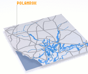 Places with similar names to Polam Rok, Senegal ::
// Pelmberg (AT)
// Plomberg (AT)
// Palmberg (DE)
// Palmberg (DE)
// Palmberg (DE)
// Plumbrook (US)
// Palma Rica (VE)
// Palmariggi (IT)
// Pillemark (DK)
Disclaimer :: Information on this page comes without warranty of any kind |
||
|
Where is Polam Rok? Elevation and coordinates ::
Latitude (lat): 14°38'0"N Longitude (lon): 16°55'0"W
Elevation (approx.): 36m (map arrows pan, magnifying glasses zoom) |
||
|
Visiting Polam Rok? Hotel/Accommodation ::
Book a hotel in Polam Rok Travel Guide ::
Buy a travel guide for Senegal rental cars ::
car rental offers GPS waypoint ::
download a GPX waypoint (PoI) of Polam Rok for your GPS receiver
|
||