|
search place name
|
||
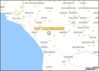
Sintiou Mbadane (Thiès, Senegal)Sintiou Mbadane is a town in the Thiès region of Senegal. An overview map of the region around Sintiou Mbadane is displayed below.
regional and 3d topo map of Sintiou Mbadane, Senegal ::
Sintiou Mbadane airports ::
The nearest airport is DKR - Dakar Leopold Sedar Senghor Intl, located 72.3 km north west of Sintiou Mbadane.
Other airports nearby include KLC - Kaolack (97.5 km east), BJL - Banjul Intl (120.9 km south), XLS - St. Louis Saint Louis (189.0 km north), ZIG - Ziguinchor (215.3 km south), Nearby towns ::
Sidibougou (1.9km south) //
Mboulèm (1.8km east) //
Ouoran (4.1km south west) //
Gagnabougou (4.1km south east) //
Fahor (5.2km north west) //
Fandane (5.6km north) //
Mbour (5.4km west) //
Mbouror (5.4km east) //
Ngogo (5.8km north) //
Nianing (5.8km south) //
Nianing Boro (7.4km south) //
Louli Mboudaye (7.4km east) //
Malikounda Sas (7.7km north west) //
Louli Mbafaye (9.1km north east) //
Ndiagne (9.2km north east) //
Gandigal (10.3km north west) //
[all distances 'as the bird flies' and approximate] 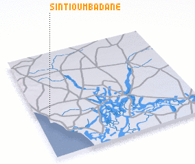 Places with similar names to Sintiou Mbadane, Senegal ::
// Sintiou Médina (SN)
// Sancha Madina (GM)
// Sinchu Medina (GM)
// Sinchã Madina (GW)
// Sinchã Madina (GW)
// Sinchã Madina (GW)
Disclaimer :: Information on this page comes without warranty of any kind |
||
|
Where is Sintiou Mbadane? Elevation and coordinates ::
Latitude (lat): 14°24'0"N Longitude (lon): 16°55'0"W
Elevation (approx.): 7m (map arrows pan, magnifying glasses zoom) |
||
|
Visiting Sintiou Mbadane? Hotel/Accommodation ::
Book a hotel in Sintiou Mbadane Travel Guide ::
Buy a travel guide for Senegal rental cars ::
car rental offers GPS waypoint ::
download a GPX waypoint (PoI) of Sintiou Mbadane for your GPS receiver
|
||