|
search place name
|
||
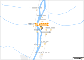
Al Ḩarāz (Al Kharţūm, Sudan)Al Ḩarāz is a town in the Al Kharţūm region of Sudan. An overview map of the region around Al Ḩarāz is displayed below.
regional and 3d topo map of Al Ḩarāz, Sudan ::
Al Ḩarāz airports ::
The nearest airport is KRT - Khartoum, located 23.3 km south of Al Ḩarāz.
Nearby towns ::
Surūjīyah (1.8km east) //
Karari (2.3km west) //
Abū Ḩalīmah (2.6km south east) //
Ja‘līyīn (3.7km north) //
Durayshāb (3.7km north) //
Fakī Hāshim (3.7km north) //
Dabbah (3.8km north) //
Khawjalāb (3.8km east) //
Wādī Sayyidnā (4.0km north west) //
Khulaylah (5.6km north) //
Al Ḩulayfī (6.3km south) //
Al Uzayriqāb (7.4km south) //
‘Ujayjah (7.6km south) //
[all distances 'as the bird flies' and approximate] 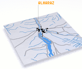 Places with similar names to Al Ḩarāz, Sudan ::
Disclaimer :: Information on this page comes without warranty of any kind |
||
|
Where is Al Ḩarāz? Elevation and coordinates ::
Latitude (lat): 15°48'0"N Longitude (lon): 32°33'0"E
Elevation (approx.): 380m (map arrows pan, magnifying glasses zoom) |
||
|
Visiting Al Ḩarāz? Hotel/Accommodation ::
Book a hotel in Al Ḩarāz Travel Guide ::
Buy a travel guide for Sudan rental cars ::
car rental offers GPS waypoint ::
download a GPX waypoint (PoI) of Al Ḩarāz for your GPS receiver
|
||