|
search place name
|
||
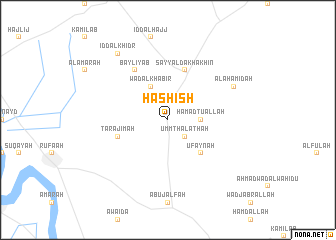
Ḩashīsh ((( Al Wusţá )), Sudan)Ḩashīsh is a town in the (( Al Wusţá )) region of Sudan. An overview map of the region around Ḩashīsh is displayed below.
regional and 3d topo map of Ḩashīsh, Sudan ::
Ḩashīsh airports ::
The nearest airport is KRT - Khartoum, located 132.7 km north west of Ḩashīsh.
Nearby towns ::
Umm Thalāthah (2.6km south east) //
Ḩamadtu Allāh (3.6km east) //
Wad al Khabīr (4.1km north west) //
‘Ufaynah (5.2km south east) //
Tarājimah (5.7km west) //
Sayyāl Dakhākhīn (5.8km north) //
Bayliyāb (6.6km north west) //
Al Aḩāmidah (8.1km north east) //
Ḩashīshāb (9.2km north west) //
‘Idd al Khiḑr (9.2km north west) //
[all distances 'as the bird flies' and approximate] 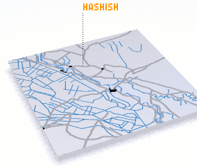 Places with similar names to Ḩashīsh, Sudan ::
// Ḩashīshah (IQ)
// Hoshcha (UA)
// Hushcha (UA)
// Hachech (ET)
// Hashash (SA)
// Ḩishāsh (SA)
// Ḩashīsh (IR)
// Huashuacha (PE)
// Hao-shou-chü (TW)
// Huo-shao-chu (TW)
Disclaimer :: Information on this page comes without warranty of any kind |
||
|
Where is Ḩashīsh? Elevation and coordinates ::
Latitude (lat): 14°48'0"N Longitude (lon): 33°29'0"E
Elevation (approx.): 409m (map arrows pan, magnifying glasses zoom) |
||
|
Visiting Ḩashīsh? Hotel/Accommodation ::
Book a hotel in Ḩashīsh Travel Guide ::
Buy a travel guide for Sudan rental cars ::
car rental offers GPS waypoint ::
download a GPX waypoint (PoI) of Ḩashīsh for your GPS receiver
|
||