|
search place name
|
||
Changachanga (Western, Zambia)Changachanga is a town in the Western region of Zambia. An overview map of the region around Changachanga is displayed below.
regional and 3d topo map of Changachanga, Zambia ::
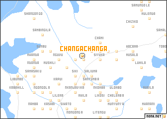
Nearby towns ::
Liapukumuka (0.0km north) //
Kalunda (1.8km west) //
Samubi (2.6km north east) //
Kambongo (3.7km south) //
Samalanda (3.7km south) //
Samuele (3.6km east) //
Siyuka (3.6km east) //
Saliuma (4.1km south east) //
Katongo (4.1km south west) //
Siki (4.1km south west) //
Simbotwe (4.0km north east) //
Ndonyo (4.0km north east) //
Chimbweta (4.0km south west) //
Chami (5.2km north east) //
Nguvu (5.4km west) //
Mulima (5.6km south) //
Santumba (5.8km south) //
Chikinina (5.8km south) //
Kambwanga (5.7km east) //
Kambyasa (5.7km east) //
Chinkumbe (6.6km south east) //
Saliyungela (7.2km east) //
Nkanjavika (7.6km south) //
Mukeche (7.4km east) //
Mushili (7.4km west) //
Liyembani (7.4km west) //
Kapui (7.7km south west) //
Nkomba (8.2km south east) //
Ulombo (10.3km south east) //
[all distances 'as the bird flies' and approximate] 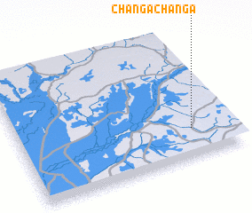 Places with similar names to Changachanga, Zambia ::
// Changchang (IN)
// Changachanga (ZM)
// Changachanga (ZM)
// Changachanga (PE)
// Chungch'ŏng (KP)
// Chung-chuang (TW)
// Chung-chuang (TW)
// Ch'eng-chung (TW)
// Ch'ing-chiang (TW)
// Chung-ch'eng (TW)
Disclaimer :: Information on this page comes without warranty of any kind |
||
|
Where is Changachanga? Elevation and coordinates ::
Latitude (lat): 14°46'0"S Longitude (lon): 23°49'0"E
Elevation (approx.): 1090m (map arrows pan, magnifying glasses zoom) |
||
|
Visiting Changachanga? Hotel/Accommodation ::
Book a hotel in Changachanga Travel Guide ::
Buy a travel guide for Zambia rental cars ::
car rental offers GPS waypoint ::
download a GPX waypoint (PoI) of Changachanga for your GPS receiver
|
||