|
search place name
|
||
Chinjenge (Western, Zambia)Chinjenge is a town in the Western region of Zambia. An overview map of the region around Chinjenge is displayed below.
regional and 3d topo map of Chinjenge, Zambia ::
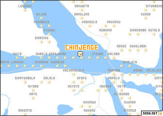
Nearby towns ::
Shongwe (0.0km north) //
Mushungwa (0.0km north) //
Limbamba (0.0km north) //
Kundendama (0.0km north) //
Mashesha (1.8km east) //
Kabela (1.8km west) //
Nakakena (1.8km west) //
Nyambe (3.6km east) //
Chiteula (3.6km east) //
Mbonge Mwemwa (3.6km west) //
Kachapulula (4.1km south west) //
Namakando (4.0km south west) //
Muwaneyi (5.4km east) //
Kayawe (5.4km east) //
Kuyewana (5.4km east) //
Samajamba (5.4km west) //
Ufufu (5.6km south) //
Siongiso (5.7km west) //
Mwendiana (5.7km west) //
Sangambo (5.8km south) //
Chimupi (5.8km south) //
Awata (7.2km east) //
Chimanya (7.4km south) //
Mpoko (7.4km south) //
Kalabo (7.2km east) //
Kapanda (7.2km west) //
Mainda (7.2km west) //
Muyoyo (7.6km south) //
Kasabi (7.6km south) //
[all distances 'as the bird flies' and approximate] 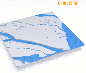
Disclaimer :: Information on this page comes without warranty of any kind |
||
|
Where is Chinjenge? Elevation and coordinates ::
Latitude (lat): 14°58'0"S Longitude (lon): 22°37'0"E
Elevation (approx.): 1023m (map arrows pan, magnifying glasses zoom) |
||
|
Visiting Chinjenge? Hotel/Accommodation ::
Book a hotel in Chinjenge Travel Guide ::
Buy a travel guide for Zambia rental cars ::
car rental offers GPS waypoint ::
download a GPX waypoint (PoI) of Chinjenge for your GPS receiver
|
||