|
search place name
|
||
Chituta (Northern, Zambia)Chituta is a town in the Northern region of Zambia. An overview map of the region around Chituta is displayed below.
regional and 3d topo map of Chituta, Zambia ::
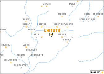
Nearby towns ::
Pensulo (3.7km east) //
Lazalo (3.7km west) //
Kapufi (4.1km north east) //
Lupasha (5.2km north west) //
Teta (5.5km west) //
Kazwila (5.8km east) //
Chewe Kaniki (6.6km north east) //
Mukuntansela (7.3km east) //
Kapoli (7.5km west) //
Kamuchinka (8.3km north east) //
Samamba (8.3km north east) //
Chalikosa (9.2km south west) //
John Chivuta (9.2km south west) //
[all distances 'as the bird flies' and approximate] 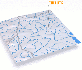 Places with similar names to Chituta, Zambia ::
// Chiatat (MA)
// Tiouddit (MA)
// Shadowwood (US)
// Chitid (RO)
// Chododa (RU)
// Shadīdah (IQ)
// Chāh Tūt (IR)
// Shadow Wood (US)
// Shadow Wood (US)
// Chhātādda (BD)
Disclaimer :: Information on this page comes without warranty of any kind |
||
|
Where is Chituta? Elevation and coordinates ::
Latitude (lat): 9°26'0"S Longitude (lon): 31°45'0"E
Elevation (approx.): 1436m (map arrows pan, magnifying glasses zoom) |
||
|
Visiting Chituta? Hotel/Accommodation ::
Book a hotel in Chituta Travel Guide ::
Buy a travel guide for Zambia rental cars ::
car rental offers GPS waypoint ::
download a GPX waypoint (PoI) of Chituta for your GPS receiver
|
||