|
search place name
|
||
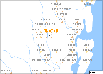
Mgeyeni (Tanzania)Mgeyeni is a town in Tanzania. An overview map of the region around Mgeyeni is displayed below.
regional and 3d topo map of Mgeyeni, Tanzania ::
Mgeyeni airports ::
The nearest airport is TGT - Tanga, located 34.2 km south of Mgeyeni.
Other airports nearby include PMA - Pemba (96.3 km south east), MBA - Mombasa Moi Intl (100.3 km north east), ZNZ - Zanzibar (159.9 km south), Nearby towns ::
Magauni (0.0km north) //
Muembem (0.0km north) //
Mzingi (1.9km north) //
Kibanduni (1.8km west) //
Mawaru (2.6km north west) //
Kindunguni (2.6km north east) //
Mapeko (3.7km north) //
Ngojeni (3.7km west) //
Magodi (3.7km west) //
Matope (4.1km north west) //
Changanyiko (5.2km north west) //
Merwa (5.2km south west) //
Mekunde (5.5km west) //
Kidutani (5.8km west) //
Vyogoloni (5.9km north) //
Mabayani (5.9km north) //
Maweni (5.9km north) //
Parungu (5.9km south) //
Kinyatu (6.7km south west) //
Hundu (6.7km north east) //
Petukiza (7.4km east) //
Mkinga (7.4km south) //
Kiponda (7.4km south) //
Mangalia (7.6km north) //
Mlamba (7.6km south) //
Makoveni (7.6km south) //
Mabosa (7.6km east) //
Vuo (7.6km east) //
Nikanyewe (8.3km north east) //
[all distances 'as the bird flies' and approximate]  Places with similar names to Mgeyeni, Tanzania ::
Disclaimer :: Information on this page comes without warranty of any kind |
||
|
Where is Mgeyeni? Elevation and coordinates ::
Latitude (lat): 4°47'0"S Longitude (lon): 39°5'0"E
Elevation (approx.): 95m (map arrows pan, magnifying glasses zoom) |
||
|
Visiting Mgeyeni? Hotel/Accommodation ::
Book a hotel in Mgeyeni Travel Guide ::
Buy a travel guide for Tanzania rental cars ::
car rental offers GPS waypoint ::
download a GPX waypoint (PoI) of Mgeyeni for your GPS receiver
|
||