|
search place name
|
||
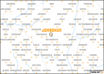
Jombohun (Eastern, Sierra Leone)Jombohun is a town in the Eastern region of Sierra Leone. An overview map of the region around Jombohun is displayed below.
regional and 3d topo map of Jombohun, Sierra Leone ::
Jombohun airports ::
The nearest airport is FNA - Freetown Lungi, located 200.4 km west of Jombohun.
Other airports nearby include FAA - Faranah (211.6 km north), MLW - Monrovia Spriggs Payne (227.0 km south), ROB - Monrovia Roberts Intl (249.9 km south east), Nearby towns ::
Banyamahun (1.8km west) //
Poyama-poya (1.9km south) //
Giebu (1.9km north) //
Komandu (2.6km north west) //
Blama (2.6km south east) //
Periwahun (3.7km west) //
Gumahun (4.1km south west) //
Korkorti (4.1km south east) //
Laiama (4.1km north east) //
Valama (5.5km east) //
Koyama (5.9km north) //
Katima (5.9km north) //
Kundawma (5.8km west) //
Foya (5.9km south) //
Njala (6.6km south west) //
Tungie (6.7km north west) //
Gbitima (6.7km south west) //
Naiagolehun (6.7km south west) //
Jagbwema (6.6km south east) //
Bendu (6.7km south east) //
Fala (6.7km north east) //
Naiagolehun (7.3km west) //
Bama (7.4km south) //
Garwama (7.3km east) //
Gendema (7.3km east) //
Kobundala (7.6km south) //
Gbarama (7.6km west) //
Simabu (7.6km south) //
Jerihun (7.6km east) //
[all distances 'as the bird flies' and approximate]  Places with similar names to Jombohun, Sierra Leone ::
Disclaimer :: Information on this page comes without warranty of any kind |
||
|
Where is Jombohun? Elevation and coordinates ::
Latitude (lat): 8°14'0"N Longitude (lon): 11°25'0"W
Elevation (approx.): 323m (map arrows pan, magnifying glasses zoom) |
||
|
Visiting Jombohun? Hotel/Accommodation ::
Book a hotel in Jombohun Travel Guide ::
rental cars ::
car rental offers GPS waypoint ::
download a GPX waypoint (PoI) of Jombohun for your GPS receiver
|
||