|
search place name
|
||
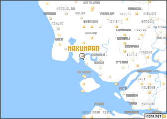
Makumpan (Northern, Sierra Leone)Makumpan is a town in the Northern region of Sierra Leone. An overview map of the region around Makumpan is displayed below.
regional and 3d topo map of Makumpan, Sierra Leone ::
Makumpan airports ::
The nearest airport is FNA - Freetown Lungi, located 37.1 km south of Makumpan.
Other airports nearby include FIG - Fira Fria (159.2 km north), Nearby towns ::
Mayoro (1.1km south east) //
Lenkenboli (3.7km south) //
Yeligban (3.7km north) //
Pomwalal (3.7km east) //
Matanok (4.0km south) //
Bonga (4.1km south east) //
Mahela (4.7km north west) //
Kipimp (5.0km south east) //
Tongbai (5.2km north) //
Mateti (5.6km south) //
Kortimaw (5.6km south) //
Saka (6.3km north west) //
Mawabul (7.1km south) //
Balansera (7.0km south east) //
Pamaro (7.4km north) //
Sheakaia (7.6km north) //
Rokai (7.8km north west) //
Ropoint (7.8km north west) //
Kila (8.3km north east) //
Makuma (8.9km north west) //
Kychom (8.9km east) //
Kuikonki (9.2km south east) //
Moribaia (10.4km north east) //
[all distances 'as the bird flies' and approximate] 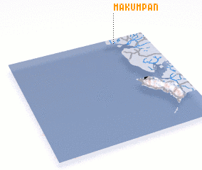 Places with similar names to Makumpan, Sierra Leone ::
// Meguião Mupane (MZ)
Disclaimer :: Information on this page comes without warranty of any kind |
||
|
Where is Makumpan? Elevation and coordinates ::
Latitude (lat): 8°57'0"N Longitude (lon): 13°14'0"W
(map arrows pan, magnifying glasses zoom) |
||
|
Visiting Makumpan? Hotel/Accommodation ::
Book a hotel in Makumpan Travel Guide ::
rental cars ::
car rental offers GPS waypoint ::
download a GPX waypoint (PoI) of Makumpan for your GPS receiver
|
||